| |
|
|
|
|
|
|
|
|
|
|
|
|
|
|
|
|
|
|
|
|
|
|
MOUNTAINS IN VERMONT
The
Appalachian Mountains extend into Vermont. Here is a list of the
heights of the mountains, starting with Mount Mansfield, the highest
at 4393 feet above sea level. Ski areas on mountains in red. See the
list :
http://skicentral.com/vermont-map.html
|
Mount Mansfield |
Stowe |
4,393 |
1,339 |
Underhill |
|
Killington Peak |
Killington |
4,235 |
1,291 |
Killington |
|
Mount Ellen |
Sugarbush |
4,083 |
1,244 |
Warren |
|
Camel's Hump |
|
4,083 |
1,244 |
Duxbury |
|
Mount Abraham |
|
4,006 |
1,221 |
Lincoln |
|
Lincoln Peak |
Sugarbush |
3,975 |
1,212 |
Warren |
|
Pico Peak |
Pico |
3,957 |
1,206 |
Killington |
|
Stratton Mountain |
Stratton |
3,940 |
1,201 |
Stratton |
|
Bear Head |
|
3,940 |
1,201 |
Enosburg Falls |
|
Little Killington |
Killington |
3,939 |
1,201 |
Mendon |
|
Jay Peak |
Jay |
3,858 |
1,176 |
Westfield |
|
Equinox Mountain |
|
3,840 |
1,170 |
Manchester |
|
Mendon Peak |
|
3,840 |
1,170 |
Mendon |
|
Bread Loaf Mountain |
|
3,835 |
1,169 |
Ripton |
|
Nancy Hanks Peak |
|
3,812 |
1,162 |
Warren |
|
Skye Peak |
|
3,800 |
1,158 |
Killington |
|
Big
Jay |
|
3,786 |
1,154 |
Montgomery |
|
Mount Wilson |
|
3,780 |
1,152 |
Ripton |
|
Dorset Mountain |
|
3,760 |
1,146 |
Danby |
|
Glastenbury Mountain |
|
3,748 |
1,142 |
Glastenbury |
|
Shrewsbury Peak |
|
3,720 |
1,134 |
Shrewsbury |
|
Sterling Mountain |
Stowe |
3,714 |
1,132 |
Morristown |
|
Ethan Allen Mountain |
|
3,688 |
1,124 |
Huntington |
|
Bolton Mountain |
Bolton |
3,680 |
1,122 |
Bolton |
|
Stark Mountain |
Mad River |
3,662 |
1,116 |
Fayston |
|
Mount Putnam |
|
3,642 |
1,110 |
Worcester |
|
Madonna Peak |
Smugglers |
3,640 |
1,109 |
Morristown |
|
Mount Grant |
|
3,623 |
1,104 |
Lincoln |
|
Rams Head |
Killington |
3,600 |
1,097 |
Killington |
|
Snowdon Peak |
Killington |
3,592 |
1,095 |
Killington |
|
Mount Snow |
Mount Snow |
3,586 |
1,093 |
West Dover |
|
Mount Hunger |
|
3,539 |
1,079 |
Barnard |
|
Mount Roosevelt |
|
3,528 |
1,075 |
Ripton |
|
Farr Peak |
|
3,522 |
1,074 |
Chittenden |
|
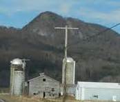
Haystack Mountain |
Now is private |
3,445 |
1,050 |
Wilmington |
|
East Mountain |
|
3,439 |
1,048 |
East Haven |
|
Peru Peak |
|
3,429 |
1,045 |
Peru |
|
Styles Peak |
|
3,394 |
1,034 |
Peru |
|
Signal Mountain |
|
3,370 |
1,027 |
Groton |
|
Mount Carmel |
|
3,365 |
1,026 |
Chittenden |
|
Belvidere Mountain |
|
3,360 |
1,024 |
Lowell |
|
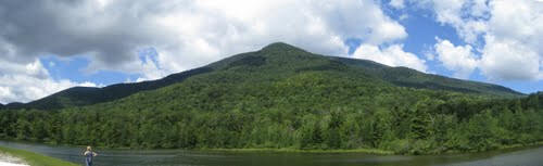
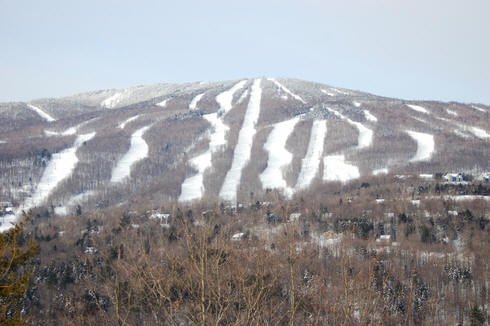
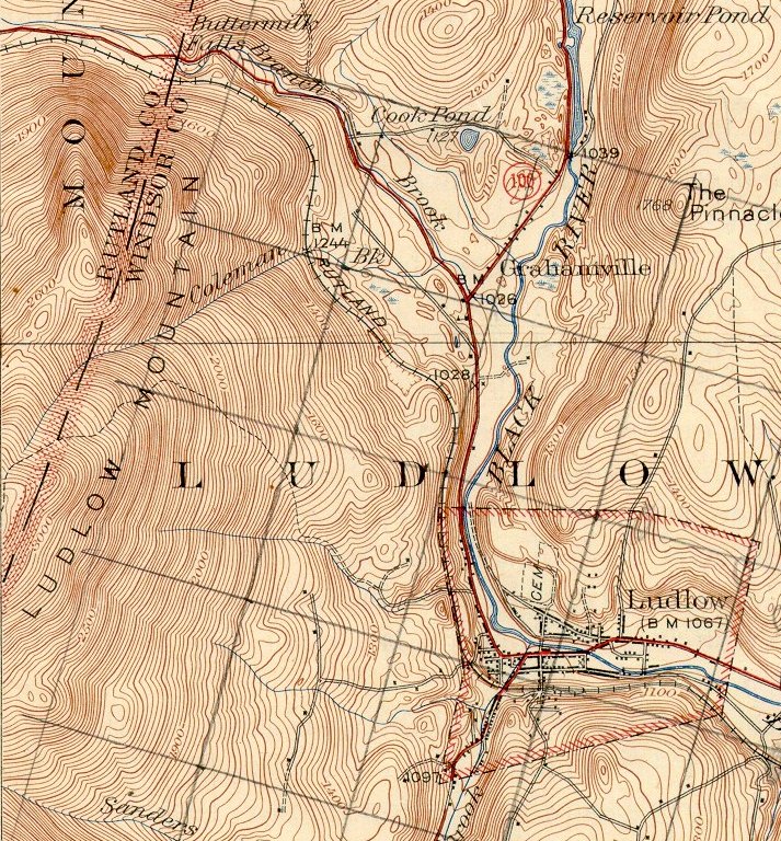
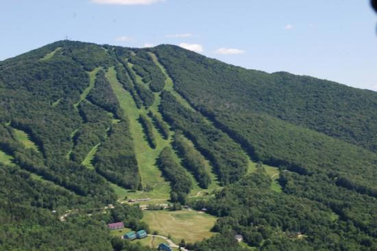
Ludlow Mountain |
Okemo |
3,344 |
1,019 |
Ludlow |
|
Gore Mountain |
|
3,332 |
1,016 |
Norton |
|
Cold Hollow Mountain |
|
3,330 |
1,015 |
Belvidere |
|
Bald Mountain |
|
3,315 |
1,010 |
Westmore |
|
Bromley Mountain |
Bromley |
3,284 |
1,001 |
Peru |
|
Worcester Mountain |
|
3,274 |
998 |
Worcester |
|
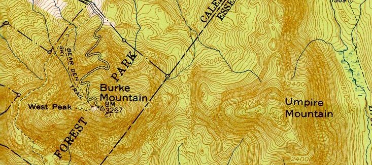
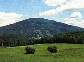
Burke Mountain |
Burke |
3,267 |
995 |
Burke |
|
Monadnock Mountain |
|
3,148 |
960 |
Lemington |
|
Mount Ascutney |
Ascutney |
3,140 |
955 |
Windsor |
|
Mount Aeolus |
|
3,125 |
953 |
Dorset |
|
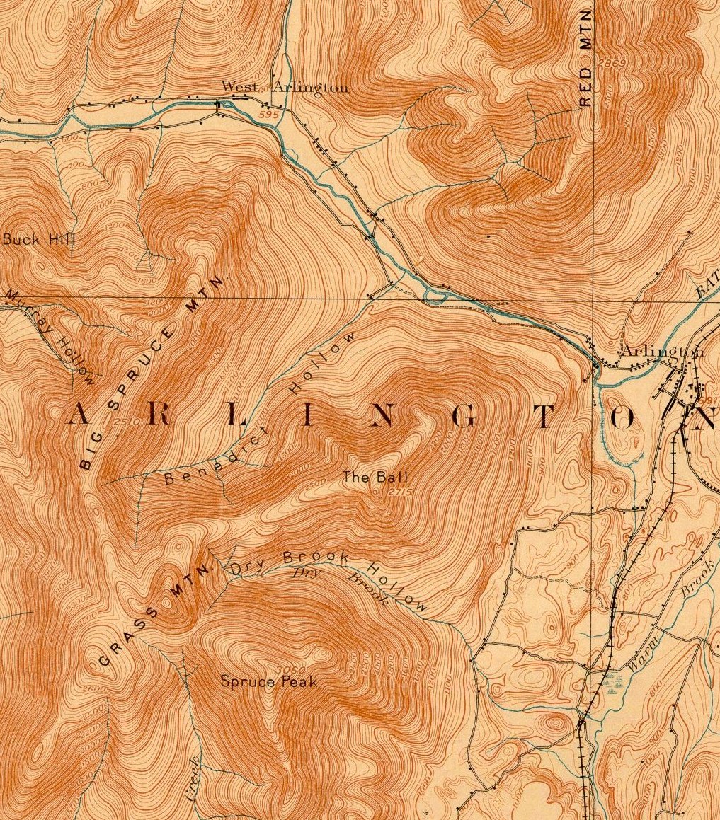
Grass Mountain |
|
3,109 |
948 |
Arlington |
|
Mount Tabor |
|
3,043 |
928 |
Peru |
|
Spruce Mountain |
|
3,037 |
926 |
Plainfield |
|
Bald Mountain |
|
2,857 |
871 |
Woodford |
|
Mount Pisgah |
|
2,752 |
839 |
Westmore |
|
Kirby Mountain |
|
2,750 |
838 |
Kirby |
|
The Dome |
|
2,748 |
837 |
Pownal |
|
Prospect Mountain |
|
2,740 |
835 |
Woodford |
|
Mount Hor |
|
2,654 |
809 |
Sutton |
|
Hogback Mountain |
Hogback # |
2,410 |
735 |
Marlboro |
|
Wheeler Mountain |
|
2,365 |
721 |
Sutton |
|
Mount Anthony |
|
2,343 |
714 |
Bennington |
|
Barton Mountain |
|
2,235 |
681 |
Barton |
|
Gile Mountain |
|
1,873 |
571 |
Norwich |
|
Mount Ephraim |
|
1,490 |
454 |
Springfield |
|
Snake Mountain |
|
1,287 |
392 |
Addison |
|
Mount Tom |
|
1,250 |
381 |
Plymouth |
# Closed
Look at 1248 Mountains in Vermont at
www.expertgps.com/data/vt/mountains.asp
Ski areas in New England, listed by vertical drop is
at:
http://en.wikipedia.org/wiki/List_of_New_England_ski_areas_by_vertical_drop
Those in Vermont are below:
# Killington, Ramshead, and Snowdon
## Mt Mansfield and Spruce Peak (Sterling Mountain)
### Originally called Mt Pisgah, now is Mt Snow.
* Located on Glebe Mountain
** Located on Worth Mountain
*** Now a 501C3 See
http://www.cochranskiarea.com/history
A listing of the physiographic regions
of Vermont is found in:
http://academics.smcvt.edu/vtgeographic/textbook/physiographic/physiographic_regions_of_vermont.htm
Also, read about the
Geology of Vermont.
MOUNTAIN ROADS
You can drive up the toll road to the
summit of Mount Washington in New Hampshire. But there are six
mountains in Vermont that have roads to the summit:
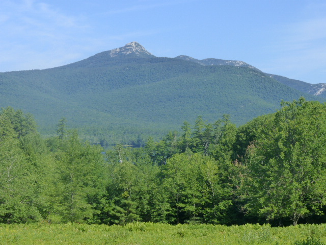
Mount Mansfield (elevation 4395')
has a 4 mile toll road built in 1856.
Mount Equinox (elevation 3848')
In Manchester, has a 5.2 mile "Skyline Drive toll road.
At 3,848 feet above sea level, the summit offers
breathtaking panoramic views of the Green, White, Adirondack, Berkshire
and Taconic mountain ranges. Several paved parking areas provide
spectacular views, but most outstanding is the Skyline Drive itself as
you drive along the crest of the mountain on your way to the summit. The
Green Mountains, The Valley of Vermont and the White Mountains of New
Hampshire may be seen to the east. The Adirondack
Mountains of New York provide the backdrop to the west, and the Taconic
and Berkshire Mountains of Massachusetts to the south. Guard rails have
been installed almost the entire length of the drive making it one of
the safest, best engineered, well constructed toll roads in the
country.
At a very early date, roads were built through the gaps on the south and
north sides of Equinox, the former being known as “Southeast Corners”
and the latter as “ Beartown”, names they retain to this day. It was not
until sometime toward the middle of the last century that a wagon road
was built to higher altitudes, when along about 1860 or 1870 Frank Orvis
and a group of Manchester residents built a road from Beartown Gap to
Lookout Rock directly above Manchester. This road , which did not start
from the bottom of the mountain nor reach the top, was approximately
1,600 feet in altitude.
The actual summit could be reached from the end of the road by a trail
about 3/4 of a mile long, but since there already was a splendid view
from Lookout Rock therefore the road was never extended beyond the rock
to the summit. A small structure known as the “Mountain House” was built
and used as a shelter for many years. Because of the costly maintenance and
the roads unsuitability to more modern traffic , this road became
obsolete in the early 1900’s and has long since fallen into disuse
although its route still can be readily discerned by foot.
Construction of Skyline drive began in 1941, but
was suspended because of the war until 1947, when it was completed.
Today it remains as the longest, privately owned, paved toll road in the
United States.
Okemo Mountain (elevation 3344') In Ludlow, has a
free 4.5 mile road that is a ski trail in the winter.
Burke Mountain (elevation 3267'). In
1860, Joseph Hall, a man who had helped build a carriage road up New
Hampshire's Mt. Washington, hacked a small road to the summit. An
improved toll road was completed in 1935 or 1939.
Mount Ascutney (elevation 3144') has a
3.7 mile toll road. See
description and
hiking trails.
The name "Ascutney" comes from the
Abenaki word
Ascutegnik, which was the name of a settlement near where the
Sugar River meets
the
Connecticut River.
The Abenaki name for the mountain is Cas-Cad-Nac, which means
"mountain of the rocky summit"
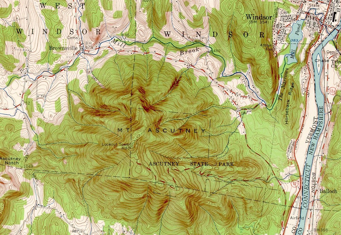
The absence of other nearby mountains
makes Ascutney a "monadnock".
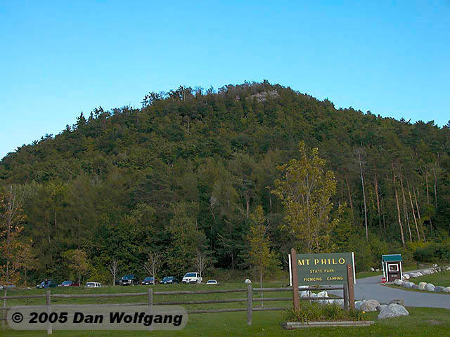
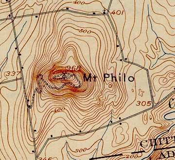
Mount Philo Located in Charlotte, (elevation 988') has a 1.4
mile toll road. Vermont's oldest state park, created in 1924, is at the summit.
The view from the summit is terrific. See
http://en.wikipedia.org/wiki/Mount_Philo_State_Park
and
http://mtphilo.com/
SONDERGELD SKIING
Don got hooked on skiing in 1956, joined the Hartford Ski Club, because
it owned a lodge near the single chairlift at Mad River Glen in Vermont
where he learned to ski. Mad River Glen was one of the first ski
areas developed in Vermont. See:
http://madriverglen.com/mountain/history The Ski Area is on
General Stark Mountain and part the scenic Monroe Skyline portion of the
Long Trail. See
http://www.starkmountain.org/
After he was married in 1957, he needed to study for actuarial exams and
could only afford to ski at most one day a week, usually a Sunday when
Don and Mary would take a day trip to Mount Snow in Southern Vermont.
Read about the history of Mt Snow (Mt Pisgah) at
http://mountsnow.com/mount-snows-history/
In 1965 we bought property in Hubbardton, VT on a lake and for
many years we had family season passes at Pico where we joined the Pico
Ski Club. All of our children became ski instructors there and
received free season passes by teaching children to ski on Sundays. The
Appalachian Trail and Long Trail are common in the southern part of
Vermont and go over Pico. Just north of Pico the Long trail
continues north ad the Appalachian Trail heads east to NH and ME.
Pico ski area at one time was owned by the parents of Andrea Mead
Lawrence. Andrea won two gold medals at the 1952 Winter Olympics
in Oslo. See
http://universalsports.com/video/countdown-to-sochi-reliving-the-glory-with-andrea-mead-lawrence/
Also see
http://picoskifoundation.org/PSEFpeak.html
MOUNTAINS and ROCKS
The Taconic Mountains extend into
Vermont as far as
Brandon.
See:
http://academics.smcvt.edu/vtgeographic/textbook/mountains/mountains_of_vermont.htm
Eagle Rock is part of the Taconics.
The three major "rock industries" are Granite, Marble and Slate.
Click here for info on the web. Granite comes from the area around
Barre. The Rock of Ages quarry in Barre is well worth a visit. Marble
quarries are in the Rutland area. Visit the Marble Museum in Proctor.
Slate is found near Fair Haven, VT and Granville, NY. The Slate Museum in
Granville is also quite interesting. Granville has been called the
"Colored Slate Capital of the World." Quarries in the town mine
slate that
comes in colors such as green, gray, gray black, red, purple, mottled green
and purple. See
http://www.slatevalleymuseum.org/
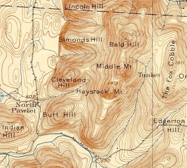
PITTSFORD RIDGE and GRISWOLD
PEAK in the TACONICS
I petitioned the State of Vermont In 2003 to
officially name two areas in the Taconics. The petition was
granted.
One purpose was to request that the ridge, which
separates Hubbardton from Pittsford, and lies between Grandpas Knob and
Biddie Knob, be named Pittsford Ridge. History books written about the Battle of Hubbardton,
fought on July 7, 1777, refer to Pittsford Ridge, but the name does
not appear on maps.
The second purpose of the petition was to request
that the highest point at the south end of Pittsford Ridge in
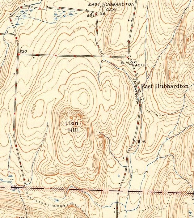
Hubbardton's South East corner, be officially named Griswold Peak. The 1897
US Geological Survey shows its elevation at 2100 feet (the 1946 survey
shows it at 2006 feet).
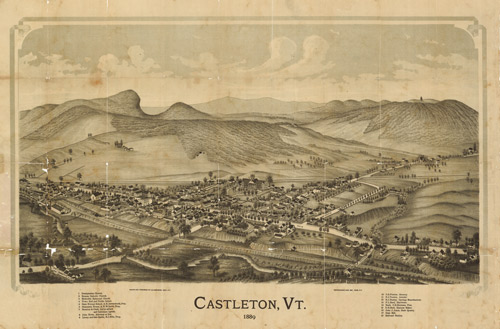
The Andersons, who live on the East Hubbardton Road
in Castleton, VT, own property in Castleton up to the Hubbardton line
plus 150 acres in the south eastern corner of Hubbardton, that was owned
by the Griswold family. The Griswolds sold the 150 acre parcel in 1920. Every time that property was sold it was referred to as
the "Griswold Lot". It is still referred to by that name by the
Andersons. There are no Griswolds still living in Hubbardton. The peak
is not being named after a living Griswold but for the Griswold family
that owned the property for many years in the 1800s and early 1900s.
See:
http://docs.unh.edu/towns/VermontTownList.htm
You can find Griswold Peak at 2006 elevation plus the Pittsford Ridge
area on the following 1946 topo of Proctor:
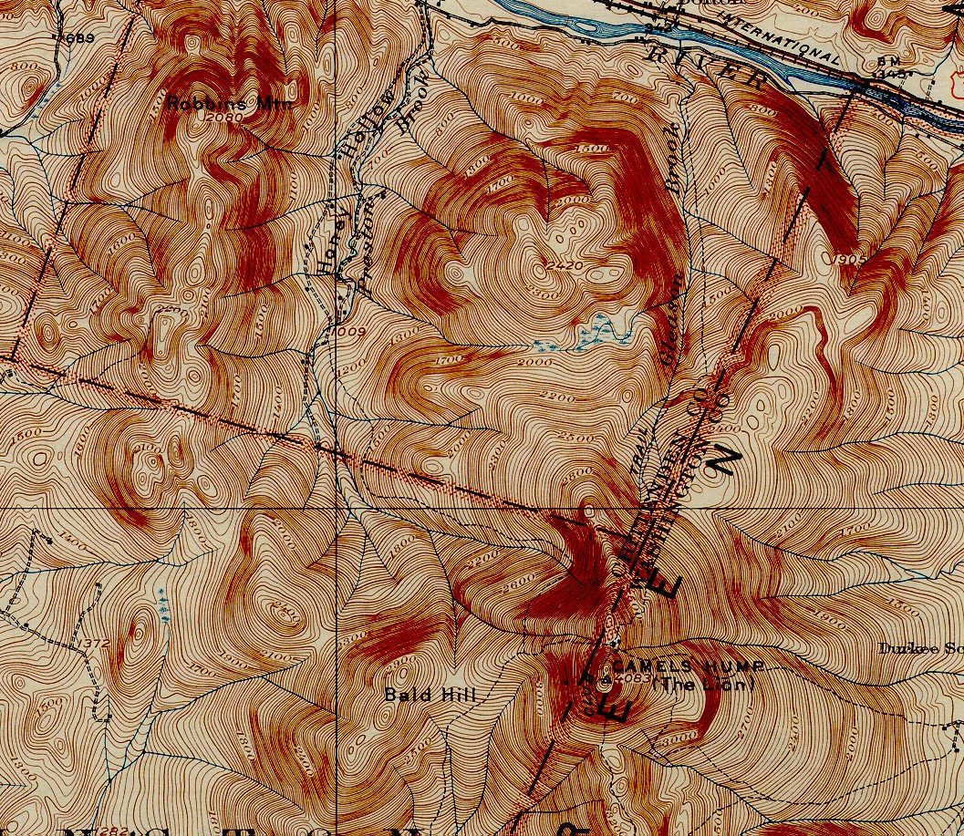
TACONIC MOUNTAINS See
pubs.usgs.gov/bul/0272/report.pdf The profile of the Taconic Range, north of the
Massachusetts border, is cut and eroded by the
Hoosic River as
it turns west and then south toward its confluence with the Hudson
River, and by its tributary rivers in the vicinity of
Bennington, Vermont.
Mount Anthony 2,320 feet, notable for its caves, stands as a satellite
peak above the surrounding eroded terrain.
North of Bennington, the taconic range
gradually rises to its highest prominence. A notable summit in the
Taconics is
Grass Mountain
at
3,109 feet in elevation in Arlington.. It is southwest of Mount
Equinox. See topo below.
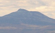
Mount Equinox
in Manchester, at 3,850 feet, is the highest point of the Taconic
Mountains in Vermont. See
www.equinoxmountain.com/mountain_statistics.php Also see topo
of Mount Equinox below.
Green Peak (Mount
Aeolus) is to the northeast of Mount Equinox..
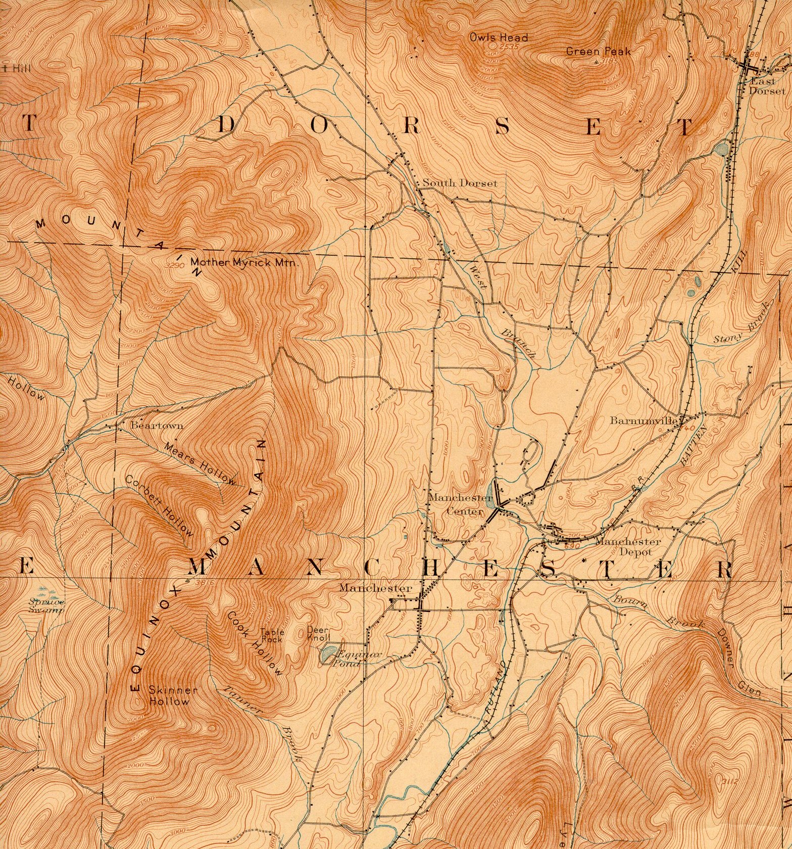
Mount Aeolus is northeast of
Mount Equinox at 3,230 feet.
Its name is derived from
Aeolus, the
Greek god of the
wind. The
Board on Geographic Names
ruled in favor of the current name in 1986; prior to that time,
the mountain had also been referred to as "Green Peak" (on the
above topo map) and "Mount Eolus."
Mount Aeolus has
several defunct
limestone
quarries.
It lies 1.5 miles west of the community of
East Dorset.
Aeolus Cave is an
important
bat
hibernaculum.
Designated hiking trails are located on Mount Equinox, Dorset Mountain,
and Mount Aeolus, and several other peaks within the region.
Stay at Aerie Inn:
aerieinnofvermont. It was
the Birthplace of Bill Wilson., the co-founder of Alcoholics Anonymous. The
building was constructed and opened as a hotel in 1852 in the small Vermont marble
quarry village. The owners were the Griffith family. William
(Bill) Griffith Wilson
was
born on November 26 of 1895 on the ground floor behind the bar of the
hotel during a snow storm.
It was originally the Mount Aeolus Inn and Tavern, then the Wilson
House.
See history at https://en.wikipedia.org/wiki/Mount_Aeolus_(Vermont)
and
https://urbanpostmortem.wordpress.com/2015/07/13/between-a-rock-and-a-hard-place/ In 1942,
Fred
Pabst moved the J Bar from Mt Aeolus Ski Area to Bromley Ski Area. See
www.newenglandskihistory.com/biographies/pabstfred.php and www.vtliving.com/fredpabst/.
Citing
a lack
of snow, the Mount. Aeolus J-Bar was moved to Fred's Bromley, VT
development in 1942.
See
www.nelsap.org/vt/mtaeolus.html
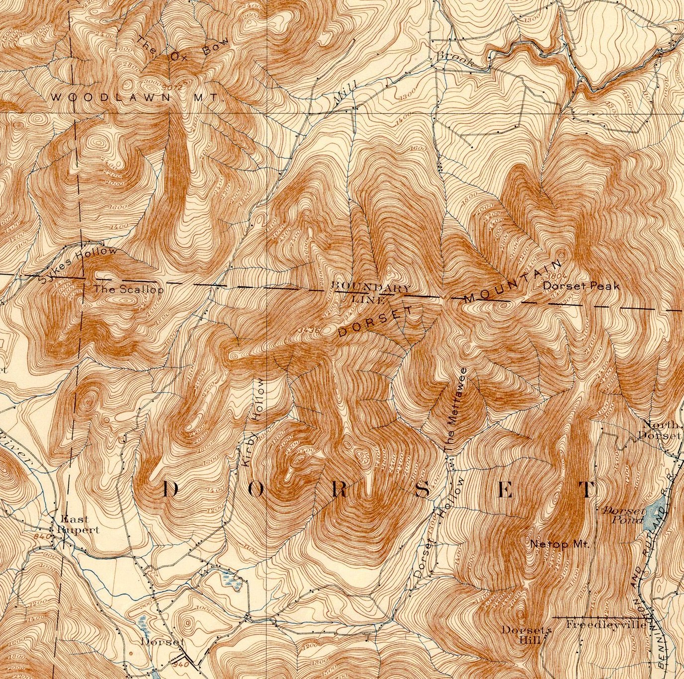
Dorset Mountain
in Danby, at
3,770 feet,
is flanked:
to the
south by Netop Mountain, Dorset Hill, and Mount
Aeolus;
to the west by The Scallop;
to the northwest by Woodlawn
Mountain; and
to the southwest by Spruce Peak and The Gallop,
subordinate peaks on the combined northern ridge of Bear Mountain and
Mother Myrick Mountain.
At 3,770 feet in elevation, Dorset
Mountain was proposed as
a ski area called "Dorset Hollow" with over 3,000 vertical feet which
would have made it the larrgest in Eastern US. The
overall project called for one aerial tramway, nine double chairlifts,
two T-Bars, four base lodges, 16 miles of ski trails, and 70 acres of
open slopes, covering six mountain peaks. In addition to the ski
facilities, a golf course, tennis courts, pools, horse stables, a
village, 100 chalets, and up to 250 hotel rooms. The developers, Dorset
Associates, Inc., were in ownership and/or control of the 3,000 acres
slated for the project which died around
1966.See www.newenglandskihistory.com/cancelledskiareas/Vermont/dorsethollow.php The
first phase of development would have been on 2867 foot high Netop
Mountain
See www.happyvermont.com/2014/06/03/dorset-hollow-ski-area-never-came/
Below is a topo that includes Dorset
Mountain (and Dorset
Peak) and Netop Mountain to
the south.
Immediately north of Danby,
Vermont, the Taconic Range
broadens and becomes shorter. It exhibits several parallel ridgelines,
dominated to the west by mountains composed of slate and
similar rock, most notably the ridgeline of Saint Catherine Mountain
1,200 feet, with its conspicuous 5-mile long cliff face visible from Wellsand Poultney.
The area around Lake
Saint Catherine contains
extensive slate quarries.
The ridgeline to the east, composed of schist and phyllite,
is dominated by the 7-mile escarpment of Tinmouth
Mountain 2,835 feet,
overlooking the Valley of Vermont to the east in the town of Tinmouth.
Near the end of the range, in the
vicinity of Rutland,
Vermont, the Taconic
Mountains show several prominent peaks with dramatic, irregular cliff
faces clearly visible from U.S.
Route 4 west
of the city of Rutland; these include Herrick
Mountain 2,726 feet; Grandpa's
Knob 1,976 feet, the
former site of the Smith-Putnam
wind turbine, the first
large-scale electricity-producing wind
turbine; and the butte-like
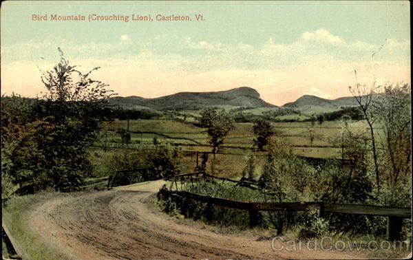
Bird Mountain (also calledBirdseye Mountain) 2,216 feet, home of
the Bird Mountain Wildlife Management Area and notable as an important raptor migration
path and nesting site.
North of Grandpas Knob are Griswold
Peak 2,006 feet, , Mount
Zion 1,229 feet, Eagle
Rock 1,325 feet, andBiddie
Knob 2,008 feet . Also
part of the Taconic Mountains are the foothills of the Lake
Bomoseen region
west of Birdseye and Grandpa's Knob, notable for their extensive slate quarrying
operations. The Taconics end in Brandon.
North of Grandpa's Knob, the Taconic
Range soon diminishes into scattered hills which extend north into theBurlington,
Vermont region.
Isolated summits in this area include Snake
Mountain 1,281
feet, a Nature
Conservancy preserve
featuring a variety of rare and endangered species. It is
also called Grand View Mountain, an isolated mountain
located in
Addison and
Weybridge, Vermont.
It belongs to a series of
scattered hills extending from the greater
Taconic Mountains
geology. Snake Mountain contains the state of
Vermont's
1,215-acre (492 ha) Snake Mountain Wildlife Management Area and
The Nature Conservancy's
Willmarth Woods Sanctuary.[2]
Several hiking trails ascend the mountain (one climbs the western face
and the second climbs the eastern face). Seen from the west, the
mountain rises dramatically (with its prominent sheer cliffs) out of the
nearby valley making it easy to recognize from other nearby hills and
mountains.
The mountain was once the site of The Grand View
Hotel, built in 1870 by Jonas N. Smith. The hotel burned down but its
foundations and the open vista of
Lake Champlain
remain. Smith's stage coach road to the summit is now the primary
hiking trail. In memory of the hotel, the view from the summit is named
"Grand View."
Also to the north is
Mount
Philo 968
feet, home of Mount
Philo State Park with
its mountaintop campground with a short auto road to the summit. There
you have a terrific 360 degree view. These two mountains are not part of
the Taconics.
MAJOR HIKING TRAILS
Stratton Mountain Stratton Mountain
claims a unique role in hiking trail history. In 1909,
James P. Taylor
(1872–1949) was on the mountain when he conceived the idea of a trail
from
Massachusetts to
Canada, which
became Vermont's
Long Trail.
While on the summit of Stratton during the
construction of the Long Trail,
Benton MacKaye
(1879–1975) considered that it would be a good idea to have a trail
spanning the entire
Appalachian Range.
The result was the
Appalachian Trail,
a 2,170-mile (3,490 km)
National Scenic Trail
from
Georgia to
Maine. In
southern Vermont, the two trails are contiguous, crossing the summit of
Stratton from south to north. A short (.75-mile), relatively flat side
trail leads from the summit to the Stratton Mountain Resort.
Appalachian Trail This
well known trail goes from Springer Mountain in Georgia to Mount Katahdin in Maine. It is approximately 2,184 miles long. It was
completed in 1937 and took about 15 years to build. The trail passes
through the states of
Georgia,
North Carolina,
Tennessee,
Virginia,
West Virginia,
Maryland,
Pennsylvania,
New Jersey,
New York,
Connecticut,
Massachusetts,
Vermont,
New Hampshire,
and
Maine. The
Appalachian Trail, the
Continental Divide Trail
and the
Pacific Crest Trail
form what is known as the
Triple Crown of
long distance hiking in the United States. Thundering Falls east of
Long Trail Lodge:
http://www.greenmountainclub.org/news.php?id=309 Directions at
http://www.northeastwaterfalls.com/waterfall.php?num=383&p=0
Long Trail This
is a 273 mile long hiking
trail located in
Vermont, running
the north south length of the state. It is the oldest
long-distance trail
in the
United States,
constructed between 1910 and 1930 by the
Green Mountain Club.
The Long Trail traverses almost all of the Green Mountains' major
summits, including (from south to north)
Glastenbury Mountain,
Stratton Mountain,
Pico,
Killington Peak,
Mount Abraham,
Mount Ellen,
Camel's Hump,
Mount Mansfield,
and
Jay Peak.
The Long Trail was the inspiration for the Appalachian Trail,
which coincides with it for 95 miles in the southern third of the state.
The Appalachian Trail heads east to New Hampshire near the Long Trail
Lodge in Sherburne Pass just north of Pico.
If you are in the northern part of
Vermont try Belvidere Mountain.
http://www.trimbleoutdoors.com/ViewTrip/840396 and
http://www.summitpost.org/belvidere-mountain/261999
and
http://www.travelthekingdom.com/listing_detail.php?id=484 and
http://www.anr.state.vt.us/dec/geo/bmtn.htm This is part of
the Long Trail. Also see
http://www.greenmountainclub.org/page.php?id=2 Finally:
https://maps.google.com/maps/ms?ie=UTF8&oe=UTF8&msa=0&msid=110998130594565901356.000461bda8ba1146bae66&dg=feature
North Country Trail This
is a 4600 mile trail ends at Crown Point, New York. There
are plans to connect it to the
Long Trail in Weybridge,
Vermont. See
http://northcountrytrail.org/
Catamount Trail This is a 300
mile long snowshoe and cross country ski trail in Vermont. You can
travel from
Inn to Inn:
http://adventure.nationalgeographic.com/adventure/trips/americas-best-adventures/ski-catamount-trail/
Learn about the trail:
http://www.catamounttrail.org/trail/
Also see:
http://www.trailsource.com/scripts/three.asp?STATENAME=VERMONT&TYPE=HIKE
HIKING IN VERMONT
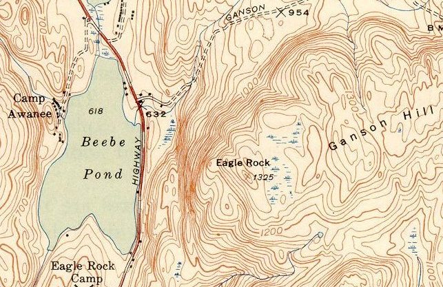
Eagle Rock Hike and High Pond Hike Take an easy hike to the summit of
Eagle Rock or to
High Pond in Sudbury (via the Nature Conservancy Trail on
Ganson Hill Road East, or via Delancey
Road). Examine the
topographical maps. Look
at two maps: Topo of High Pond and a topo of the
road
from Brandon to High Pond area. Be sure to
examine these hyperlinks. Also see info on
Ganson Hill Road and Delancey Road. About 700 feet of verical.
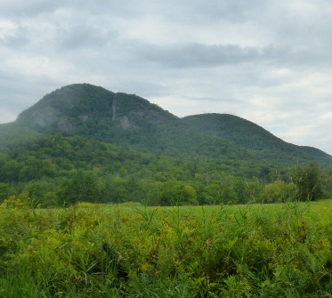
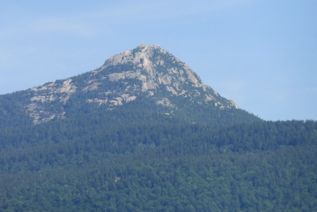
Haystack Mountain in Pawlet
Although only a modest 1919 feet elevation at the summit, the sheer
cliffs and dramatic outcrops of slate and quartzite make this a truly
memorable place to hike.
See hiking trail:
http://walkingman247.blogspot.com/2014/01/north-pawlet-hills-vermonthaystack.htm
and pawletvermont.com/tag/hiking-vermont/
 |
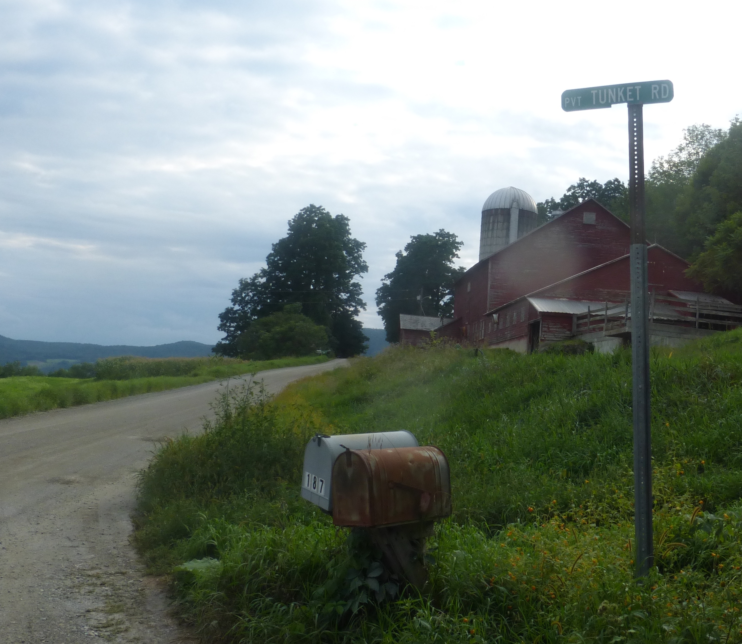
Haystack Mountain in Pawlet Vermont is a great 2 hour hike. It is 3
miles round trip and the
trail leads
you to the summit with a fantastic 360 degree view.
Once called the Gibralter of the America, Haystack affords the hardy
hiker one of the best panoramic views in Southern Vermont.
Start from the center of town and proceed 1.7 miles North on RT
30. Make a Right turn at Waite Hill road (dirt) and go exactly
1.6 miles and park at the entrance to Tunket Road, this is the
entrance to the hike. Walk up Tunket Road. |
 |
 |
 |
 |
Birdseye (or Bird) Mountain This is
just east of Castleton on Route 4A. See a terrific video on
http://www.youtube.com/watch?v=6zn4_G131NA See the Vermont
Fish and Wildlife web page that describes its 770 acre property at
http://www.vtfishandwildlife.com/library/maps/Wildlife%20Management%20Areas/Rutland%20District/Bird%20Mountain%20WMA.pdf
Deb Markowitz, former Secretary of State and currently
Secretary of Natural Resources climbed Bird Mountain the weekend of
9.29.13 in 2.5 hours. The trailhead is 1.8 miles south of Route 4A on Birdseye
Road, just east of Castleton. http://trailfinder.info/trail.php?id=385 Also Birdseye Mountain
was a former ski area
http://www.nelsap.org/vt/birdseye.html
At one time there was a ski area there. See
www.nelsap.org/vt/birdseye.html
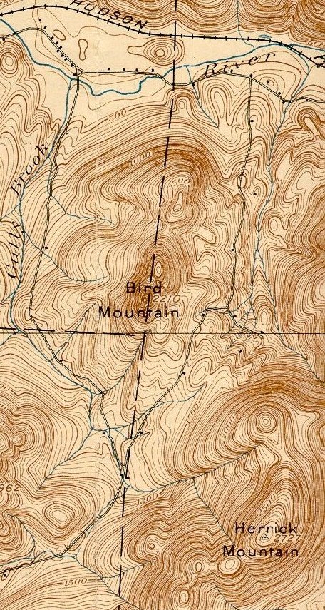
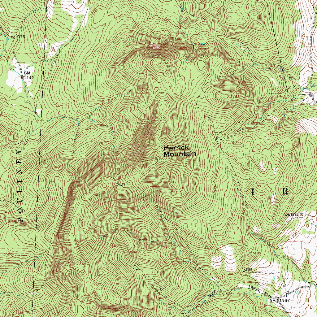
Herrick Mountain Herrick Mt
is 500 feet higher than Bird Mt in elevation.
Herrick Mountain is just south of Bird Mountain and
has a hiking trail.
Herrick Mountain is a 2,727 ft mountain peak. It ranks as the
209th highest mountain in Vermont - See more at:
http://peakery.com/herrick-mountain-vermont/#sthash.Ovp6XN3D.dpuf
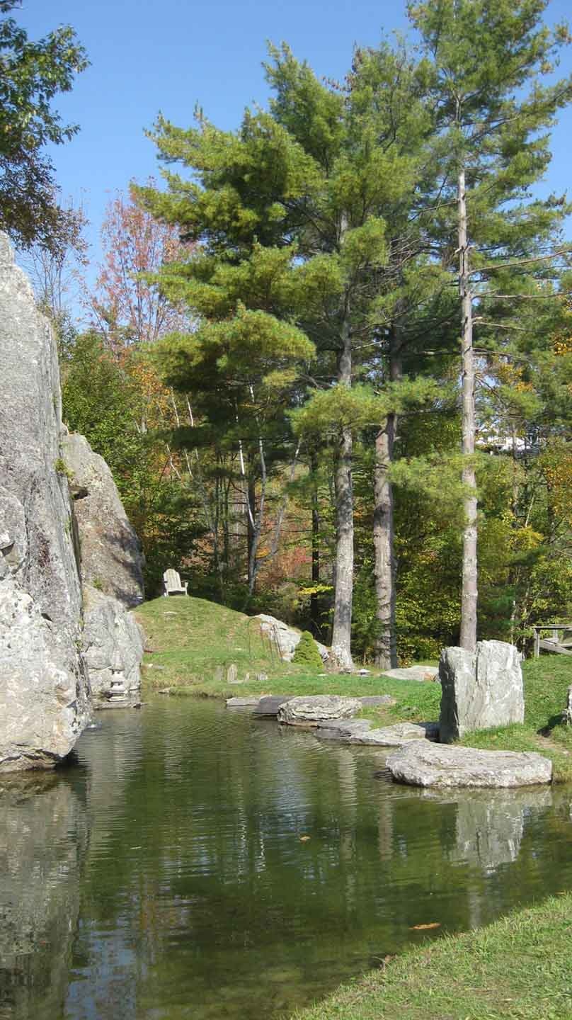
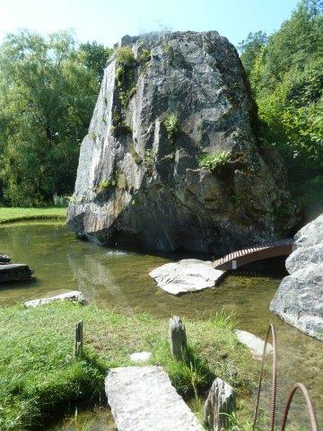
Mount Zion See
www.afana.org/taconic.htm This
beautiful site is located on Carson (Kit)
Davidson's property near the Hubbardton Battlefield. There are trails to
the top of Mount Zion and a terrific Japanese Garden on the West Side of
Monument Hill Road on 200 acres and a trail to a waterfall on the East side
of Monument Hill Road on another 200 acre parcel.
%20(VT).jpg) 
For info and directions see:
http://dayhikinginrutlandvt.blogspot.com/2011/07/mt-zion-and-japanese-gardens.html
and
http://mountaintimes.info/news/features/2013/07/hubbardton%E2%80%99s-japanese-garden-and-mt-zion-trails-offer-a-peaceful-stroll-through-a-unique-vermont-landscape/
and http://www.afana.org/taconic.htm
and
http://www.castletonspartan.com/news/mt-zion-man-offers-reflection-paradise-1.998410#.Ug52Pa7D8fc
and
http://www.vermontneighbornetwork.org/other-inspirational-stories.html
Alyssa Bennett lives on the property as its manager.
Her cell is 802-598-2404 She also works for Vermont Fish &
Wildlife Department and has helped survey Vermont’s cave-hibernating bat
species. Mickie died in 2012. Kit's phone in Hubbardton is 273-2982
See maps and
description of trails
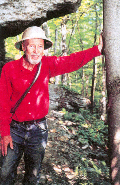
Here are
some pictures that were taken on August 16, 2013
Here is Kit and the view from his home looking south
towards his Japanese Garden. Alyssa on right..
 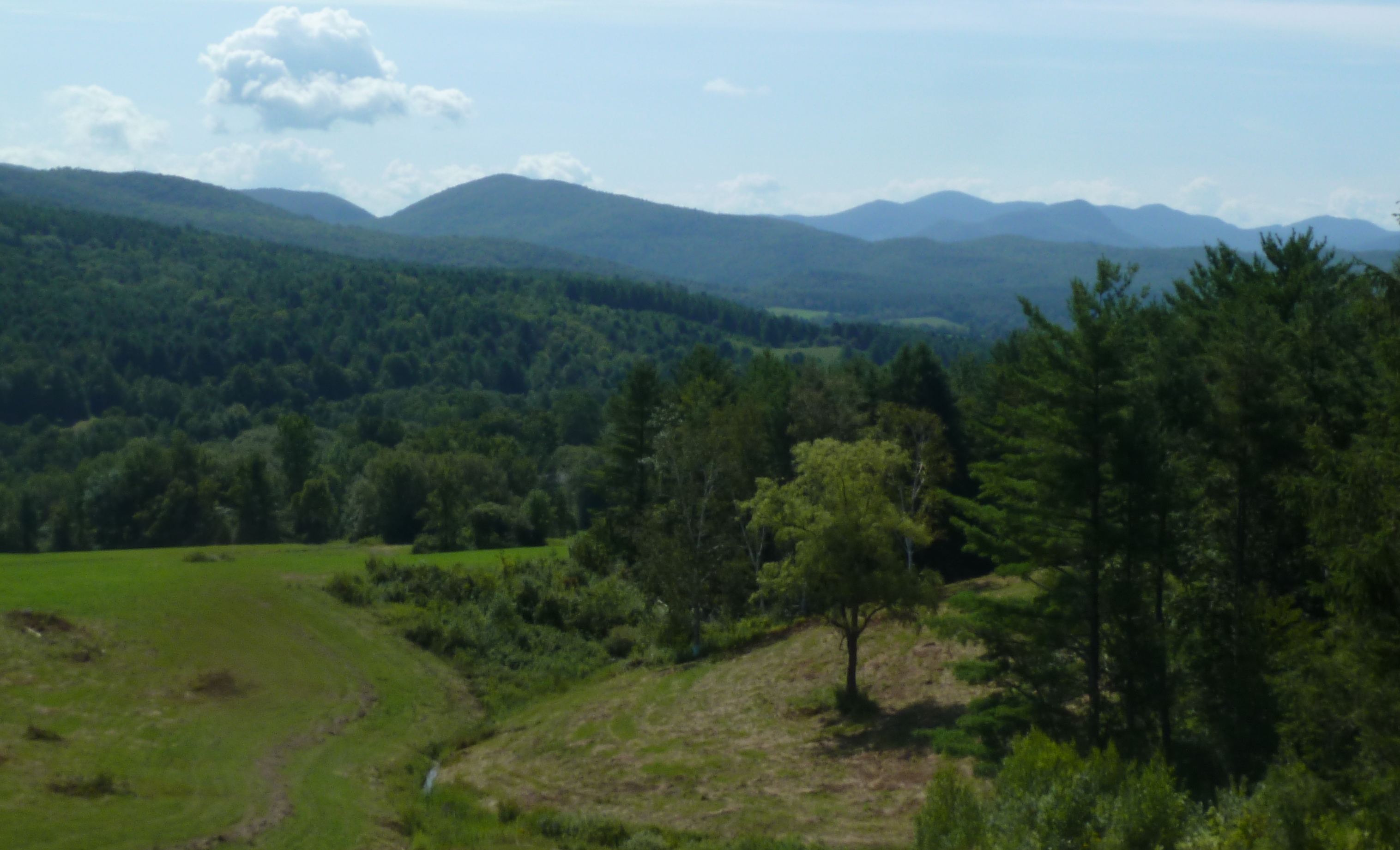 
Camel's Hump A terrific day hike is Camel's Hump which has a
granite dome which provides 360 degree views.
See Hiking info on
Camels Hump. Also, consider hiking
the "Monroe Skyline" on the Long Trail which requires two cars and
takes all day or two days. Many topological maps can be found at
http://docs.unh.edu/nhtopos/nhtopos.htm
and at
http://docs.unh.edu/towns/HubbardtonVermontMapList.htm
Mt Ascutney
See
description and
hiking trails. It
is a
monadnock located
near Ascutney, Vermont, with a summit elevation of about 3130 feet.

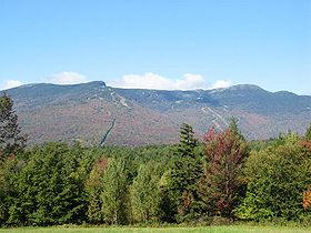
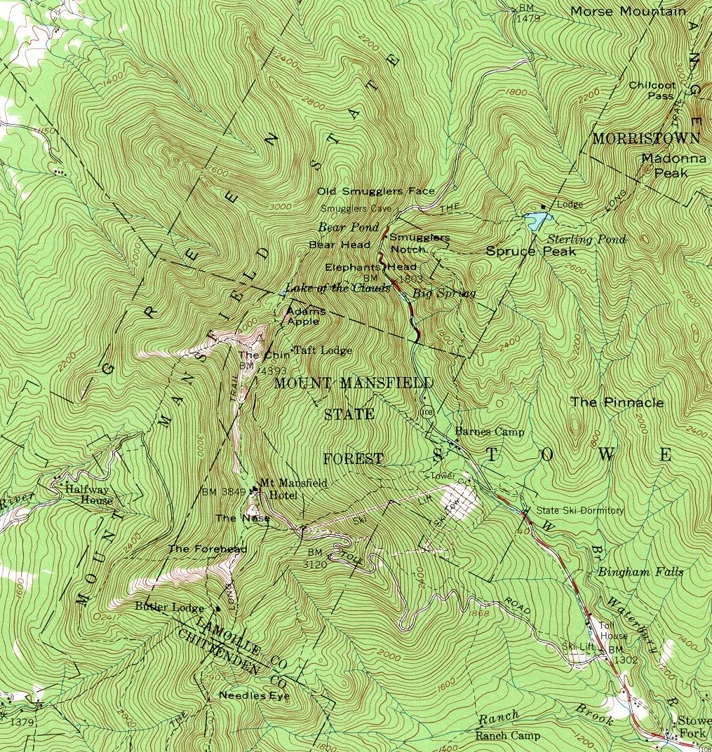
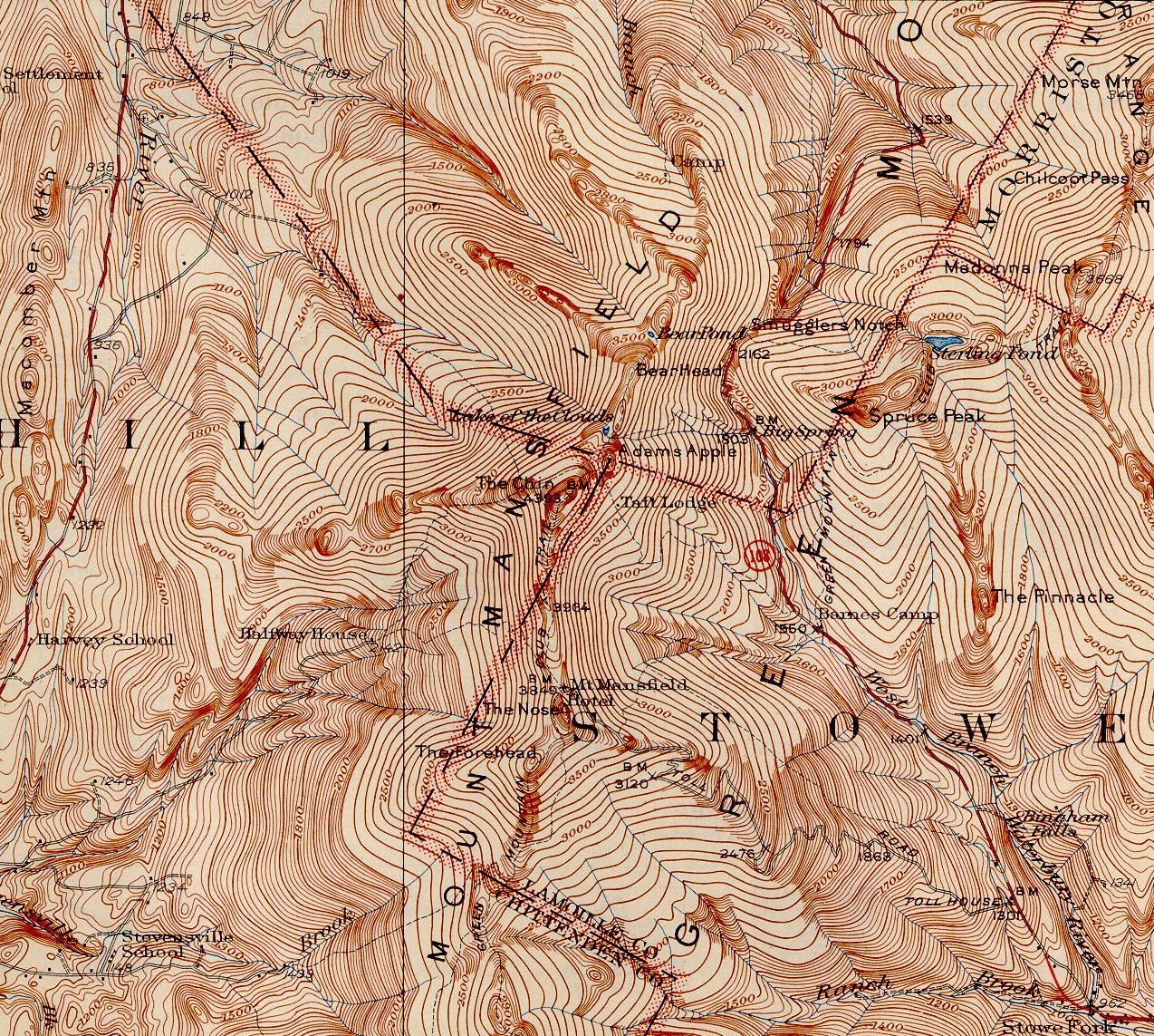
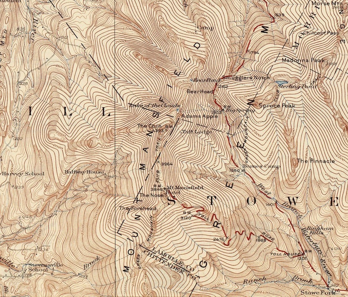
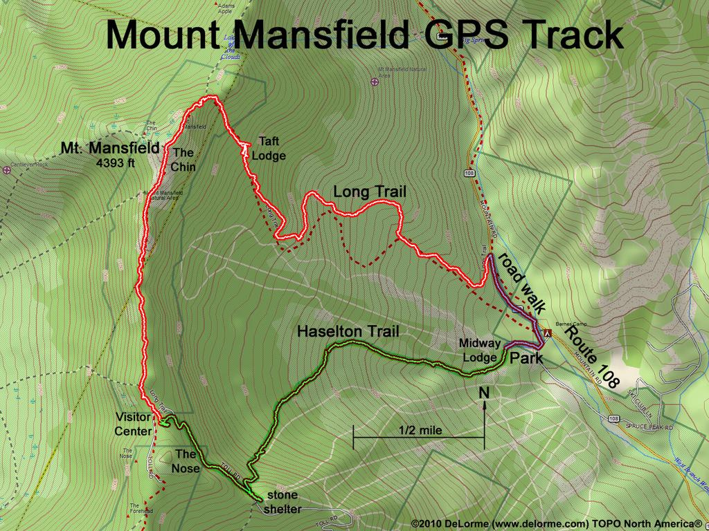
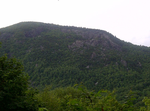
Mt Mansfield See
www.summitpost.org/mount-mansfield/150938 and
www.everytrail.com/guide/mt-mansfield and you can hike up
from Underhill State Park
www.vtstateparks.com/htm/underhill.htm

Mt Philo Also consider
Mt Philo State Park, a 45 mile drive north on Route 7 in Charlotte,
Vermont.
The 168-acre park is located atop Mt. Philo (968' elevation) and
overlooks the Lake Champlain Valley and the Adirondack Mountains of New
York. This is Vermont's oldest state park, created in 1924. There is a
1.1 mile toll road you can drive to the top for picnicking and
camping. Admission is $3. You can also hike to the summit. The views
are spectacular, with a great view of Lake Champlain.
 
Mt Horrid It is 8 miles east of Brandon
at the junction of Route 73 and the Long Trail. The elevation of the
"Cliffs of Mt Horrid" is about 3,200 feet, 1000 feet above Brandon
Gap.
http://www.summitpost.org/great-cliffs-of-mt-horrid/346627
and
http://www.rei.com/guidepost/detail/vermont/hiking/mount-horrid-and-the-great-cliff-trail/39332 Brandon Gap is one of the Gaps included in the Six Gap Bicycle ride.
http://www.northeastcycling.com/six_gaps.html
A short hike to the top of the cliffs.
Snake Mountain An hour hike to the summit.
Three miles south of the junction of Route 22A and Route 17. See
http://www.hikenewengland.com/SnakeVT080511.html
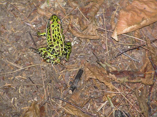
Bald
Mountain - Tim's
Trail A nearby hike is on
"Tim's Trail" an easy 2.8 mile loop along the side of Bald Mountain
in West Haven VT near Whitehall NY. Bald Mountain is 1065 feet high,
whereas the elevation of Lake Champlain is just under 100 feet. In
2007 Caitlin Whitney counted 32
Leopard Frogs on Tim's Trail. You will have great views of the
South Bay of
Lake Champlain.
From Rutland, VT, take Route 4 West.
Then from Route 4 you will cross the state line from Vermont into New
York. From the state line, continue west on Route 4 for about 5.5 miles,
crossing a set of Rail Road tracks. Turn north (right) onto Route
9A just across from where there was a garden center. Route 9A takes you
by the Skene Valley Country Club. Travel about 1 mile on Route 9A, and
then turn left onto Route 9 at the T intersection. Take the first right
onto Route 10 (Doig Street). Drive a half mile, then turn left onto the
dirt road (the paved road curves right). Cross the bridge over the
Poultney River into Vermont and turn left on the unmarked Galick Road.
(Ward
Marsh is to the right) The parking area for Tim's Trail is .7 miles
down the dirt road on the right. Please be advised that this road is
often flooded in the spring. The parking for the Susan
Bacher Memorial Trail, a 2.5 mile loop trail, is another mile down the
road from Tim's Trail. See
Topos of the area.
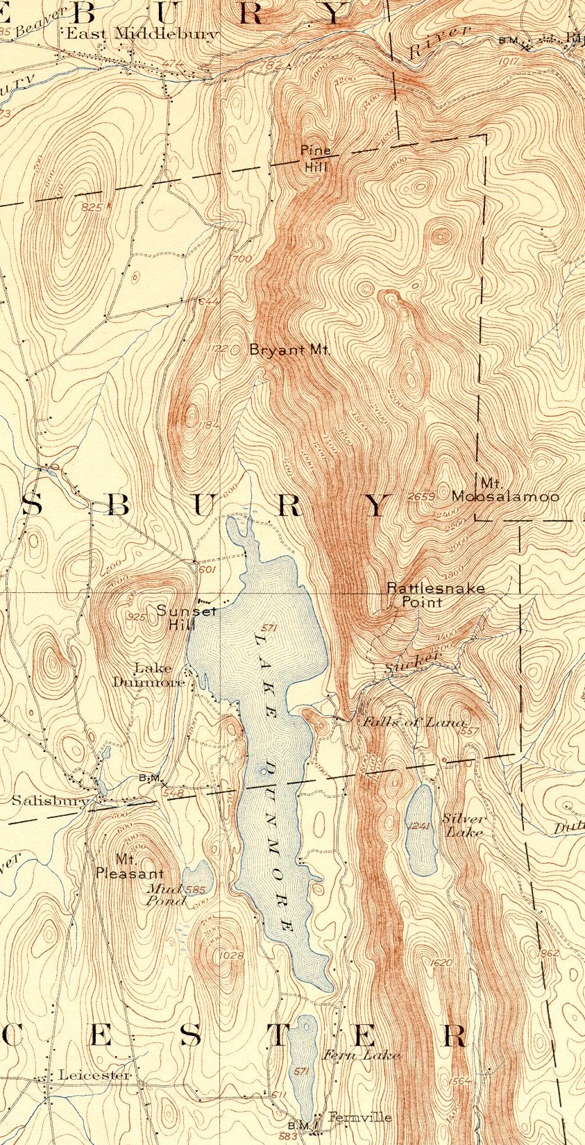
Mount Moosalamoo in Salisbury,
Vermont (See
Map)
Lake Dunmore is at 571 feet in elevation. Mount
Moosalamoo is at 2659 feet in elevation, a rise of 2088 feet.
See www.fs.usda.gov/recarea/greenmountain/recreation/recarea/?recid=64903&actid=29 and moosalamoo.org/activities/hiking/ Maps
at moosalamoo.org/wp-content/uploads/2013/11/Moosalamoo-Map.pdf
A four hour hike at www.fs.usda.gov/recarea/greenmountain/null/recarea/?recid=64933&actid=29
From East Middlebury,
travel east
on Route 125 for 6.8 miles, turn right onto Forest Road 32 and follow it
3.3 miles. Turn right onto Forest Road 24, which is the access road to
Moosalamoo Campground. Parking is on the right at 0.4 miles, outside of
the campground gate.
At Blueberry Hill in Goshen we have: www.trailfinder.info/trails/trail/blueberry-hill-area-trails
HIKING IN NEW YORK
New York: The very best hikes
are in the Adirondacks. The "High Peaks" in the Keene Valley area are
well described in
http://adirondackhikingtrails.com/ Also, visit nearby Lake
Placid. The High Peaks are "46" peaks over 4000 feet in elevation.
See
https://en.wikipedia.org/wiki/Adirondack_High_Peaks
"46" may not be absolutely correct. I have climbed Marcy, Algonquin,
Haystack, Dix, Colden, and Giant. Also see
www.adirondack.net/keene-valley/
 View from Algonquin
Peak:
(left to right) Pitchoff, Cascade, Porter, Big
Slide,
Yard, Phelps, Giant, Lower
Wolfjaw, Upper
Wolfjaw, Armstrong,Gothics, Saddleback, Basin, Nippletop and Dix, Hough, Marcy, Gray, Skylight,
and Colden (foreground)
View from Algonquin
Peak:
(left to right) Pitchoff, Cascade, Porter, Big
Slide,
Yard, Phelps, Giant, Lower
Wolfjaw, Upper
Wolfjaw, Armstrong,Gothics, Saddleback, Basin, Nippletop and Dix, Hough, Marcy, Gray, Skylight,
and Colden (foreground)
| Mountain |
Height (ft / m) |
Rank |
|
Mountain |
Height (ft / m) |
Rank |
|
Mount Marcy |
5,344 / 1,629 |
1 |
|
Seward Mountain |
4,361 / 1,329 |
24 |
|
Algonquin Peak |
5,114 / 1,559 |
2 |
|
Mount Marshall |
4,360 / 1,329 |
25 |
|
Mount Haystack |
4,960 / 1,512 |
3 |
|
Allen Mountain |
4,340 / 1,323 |
26 |
|
Mount Skylight |
4,920 / 1,500 |
4 |
|
Big Slide Mountain |
4,240 / 1,292 |
27 |
|
Whiteface Mountain |
4,867 / 1,483 |
5 |
|
Esther Mountain |
4,240 / 1,292 |
28 |
|
Dix Mountain |
4,857 / 1,480 |
6 |
|
Upper Wolfjaw Mt |
4,185 / 1,276 |
29 |
|
Gray Peak |
4,840 / 1,475 |
7 |
|
Lower Wolfjaw Mt |
4,175 / 1,273 |
30 |
|
Iroquois Peak |
4,840 / 1,475 |
8 |
|
Street Mountain |
4,166 / 1,270 |
31 |
|
Basin Mountain |
4,827 / 1,471 |
9 |
|
Phelps Mountain |
4,161 / 1,268 |
32 |
|
Gothics |
4,736 / 1,444 |
10 |
|
Mount Donaldson |
4,140 / 1,262 |
33 |
|
Mount Colden |
4,714 / 1,437 |
11 |
|
Seymour Mountain |
4,120 / 1,256 |
34 |
|
Giant Mountain |
4,627 / 1,410 |
12 |
|
Sawteeth |
4,100 / 1,250 |
35 |
|
Nippletop |
4,620 / 1,408 |
13 |
|
Cascade Mountain |
4,098 / 1,249 |
36 |
|
Santanoni Peak |
4,607 / 1,404 |
14 |
|
South Dix |
4,060 / 1,237 |
37 |
|
Mount Redfield |
4,606 / 1,404 |
15 |
|
Porter Mountain |
4,059 / 1,237 |
38 |
|
Wright Peak |
4,580 / 1,396 |
16 |
|
Mount Colvin |
4,057 / 1,236 |
39 |
|
Saddleback Mt |
4,515 / 1,376 |
17 |
|
Mount Emmons |
4,040 / 1,231 |
40 |
|
Panther Peak |
4,442 / 1,354 |
18 |
|
Dial Mountain |
4,020 / 1,225 |
41 |
|
Table Top Mountain |
4,427 / 1,349 |
19 |
|
Grace Peak |
4,012 / 1,223 |
42 |
|
Rocky Peak Ridge |
4,420 / 1,347 |
20 |
|
Blake Peak |
3,960 / 1,207 |
43 |
|
Macomb Mountain |
4,405 / 1,343 |
21 |
|
Cliff Mountain |
3,960 / 1,207 |
44 |
|
Armstrong Mountain |
4,400 / 1,341 |
22 |
|
Nye Mountain |
3,895 / 1,187 |
45 |
|
Hough Peak |
4,400 / 1,341 |
23 |
|
Couchsachraga Peak |
3,820 / 1,164 |
46 |
HIKING IN NEW HAMPSHIRE
New Hampshire: An excellent day
hike is Mt Chocorua near North Conway.
http://www.mountainsummits.com/mountains/newhampshire/chocorua.htm
For Mount Washington and other hikes, see:
http://www.slackpacker.com/map_nh.html
In Franconia
Notch a great hike is Mount Lafayette. http://www.hikenewengland.com/FranconiaRidge001021.html The Franconia Inn
http://www.franconiainn.com/ in Franconia Notch and Notchland
in Crawford Notch http://www.notchland.com/
are both terrific.
Have dinner at the the Appalachian Mountain
Club's Joe Dodge Lodge in Pinkham Notch at the base of Mount Washington.
http://www.outdoors.org/lodging/whitemountains/pinkham/before-you-go.cfm
Drive up the Auto Toll Road to the top of Mount Washington or
take the Cog Railway
http://www.thecog.com/ from Bretton Woods. Stay or dine at the
old hotel
http://www.omnihotels.com/FindAHotel/BrettonWoodsMountWashington.aspx?cid=sd_psg_g-mtwash&gclid=CPvU0Pn6orcCFUOe4AodClAAYA
Drive along Route 112, the 35 mile scenic "Kancamagus Highway"
between Lincoln and Conway, NH.
http://www.kancamagushighway.com/
OLD MAPS
All Vermont Counties www.old-maps.com/vermont/vt_cd_pdfs/
Scott 1854 Rutland County www.old-maps.com/vermont/vt_cd_pdfs/Rutland1854-lowres.pdf
Beers 1869 Rutland County www.old-maps.com/vermont/vt_cd_pdfs/Rutland1869_wb.pdf
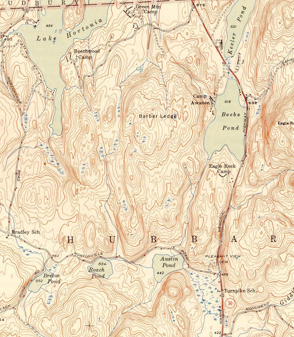
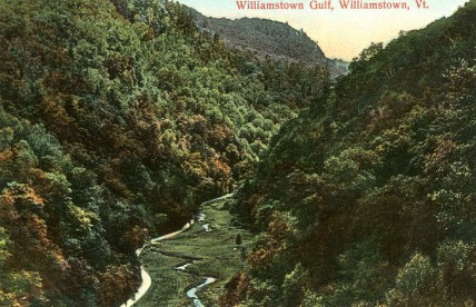
HUBBARDTON GULF (and FIVE OTHER GULFS IN VERMONT)
The Hartford (CT) Ski Club had a lodge near the
single chair lift at Mad River Glen. As a member, I learned to ski
there, but it was a long drive from Hartford. When my buddies and I got
to Granville Gulf we would stop the car and hoot and holler as we were
almost there. After Mary and I bought property at Beebe, I knew we were
almost there as we appeared to be going through a gulf, which I called
it Hubbardton Gulf. I submitted a petition to the State of Vermont to
name the area of Rt. 30 south of Beebe Pond: Hubbardton Gulf. That
name was approved in 1975. An October 16, 1975 article in the Rutland
Herald was titled Hubbardton-At
Last-Has a Gulf of Its Own. ... It now joins a select few in
Vermont: Proctorsville, Northfield, Williamstown, and Granville.
|
Ganson Hill West |
632 feet |
|
Beebe Pond |
618 feet |
|
Hortonia Road |
456 feet |
|
Austin Pond |
442 feet |
|
Change in Elevation |
176 feet |
|
Change in Elevation |
176 feet |
The Ottawa Citizen had a short article on Vermont's
Gulfs dated June 20, 1959:
http://news.google.com/newspapers?nid=2194&dat=19590620&id=80sxAAAAIBAJ&sjid=deQFAAAAIBAJ&pg=5695,1204372
Put your cursor on the Ottawa Citizen page to scroll.
Below is a 1946 topographical map of the area:
http://docs.unh.edu/towns/VermontTownList.htm
Brookfield Gulf: Route 12
runs through this gulf located south of East Roxbury.
Granville Gulf: The Mad
River flows north along Route 100 in the gulf, then
through the towns of Warren,
Waitsfield,
and
Moretown
before entering the Winooski River just downstream from
Middlesex,
and then to Lake Champlain. (The beautiful 35 foot high Moss
Glen Falls are located in Granville Gulf. There is another 125 foot
high Moss Glen Falls in Stowe.)
Hubbardton Gulf: Route 30
runs through this small gulf north of Route 141.
Northfield Gulf: The
Dog River flows north through the gulf along Route 12 to
the Winooski River in Montpelier and then flows west into Lake
Champlain.
Proctorsville Gulf: The
Williams River runs from Andover through a corner of Ludlow and
then along Route 103 into the bottom of the gulf to Chester
and into the Connecticut River in Rockingham. (The Black River in
Ludlow follows Route 103 though Ludlow and then east along Route 131
through the Cavendish Gorge to Perkinsville then south to
Springfield and then east into the Connecticut River.)
Williamstown Gulf: The
Stevens River flows north along Route 14 though the gulf
to Williamstown and then into the Winooski River in Barre, then west
to Lake Champlain.
VERMONT'S GAPS AND NOTCHES (Gorges, Gulfs,
Hollows, or Valleys are not listed)
http://vermont.hometownlocator.com/features/physical,class,gap.cfm
Data below is sorted by name and also by county.
Topo Maps in Vermont:
http://www.topozone.com/states/Vermont.asp
Search Counties by any of the following categories. The
following is from Rutland County, but Gulfs, Gaps, Gorges, Glens,
Hollows, and Valleys are shown in the last category: "Valley".
MT EVEREST is 29,035 feet high
http://iinterestingfacts.blogspot.com/2010/03/interesting-facts-about-mount-everest.html
MT MCKINLEY now renamed DENALI is 20,310 feet high
http://www.livescience.com/40595-denali-mount-mckinley.html
http://news.yahoo.com/white-house-says-mount-mckinley-renamed-denali-210234767.html;_ylt=A0LEVkAJAPNVpkYALhgPxQt.;_ylu=X3oDMTEzNjdzc3M0BGNvbG8DYmYxBHBvcwMyBHZ0aWQDRkZVSUMwXzEEc2VjA3Ny#
BASE TO PEAK VERTICAL
www.webodysseum.com/technologyscience/the-worlds-tallest-mountain-from-base-to-peak/
________________________________
Home | Vermont Sightseeing | Vermont: Fauna & Flora | Vermont Lakes & Rivers | Vermont Mountains & Hiking | Vermont History | Vermont Beebe Pond & Hubbardton | Vermont Properties
|
| |
|
|
|
|

