| |
|
|
|
|
|
|
|
|
|
|
|
|
|
|
|
|
|
|
|
|
|
|
NEW HAMPSHIRE LAND GRANTS
http://en.wikipedia.org/wiki/New_Hampshire_Grants
http://freepages.genealogy.rootsweb.ancestry.com/~vermontgenealogyresources/NHgrants.htm
Between January 1749 and October 1764, New Hampshire's Governor
Benning Wentworth issued
135 grants for land in what is now known as
Vermont. 128 of these grant towns still exist.(see above).
Hubbardton and
Dunbar were the last two grants given on June 15, 1764.
Each
grant's 6 mile by 6 mile location was defined in terms of a corner of an
existing grant.
Hubbardton was short changed as there was not quite
enough space to squeeze it between
Castleton
and Sudbury. This left no room at all for Dunbar, the town that
never was, except on paper.
Hubbardton was 250 years old in
2014, Sudbury and Orwell celebrate their 250 years in 2013, and
Castleton was 250 years old in 2012.
VERMONT:
BOUNDARIES AND ITS HISTORY AS A REPUBLIC
Its
Southeast corner has an interesting history.
Three colonies (MA, NH, & NY) were not sure of their boundaries.
In 1741 MA hired a surveyor, Richard Hazen, to determine
the boundary between MA and NH.
The result is referred to as
Hazen's Line. Vernon
ended up north of that line.
NY thought its eastern boundary was
the Connecticut River. NH thought its western boundary was
near Lake
Champlain. Although NH Governor gave out many land grants in what
is now VT.
NY disputed that. Ethan Allen's Green Mountain Boys were
formed to keep the "Yorkers "from
occupying land already granted by the
NH Governor. The King decided in NY's favor.
Then the
Revolutionary War intervened. Vermont declared its independence from New York and formed a
Republic of the disputed territory. The Republic of New Connecticut
was proclaimed on January 15, 1777 and was renamed the Republic of
Vermont on June 4, 1777. It lasted until March 4, 1791 when
Vermont entered the Union. It functioned as an independent Republic
during the war and until it became the 14th state on March
4, 1791.
Thomas Chittenden was the Governor of the Republic
for its 14 years.
He became the first Governor of the State, serving for 8 more years.
Vermont's northern border is the 45th
parallel, sort of. Read about
Fort Blunder.
Strangely, the VT
NH Border is at the low water mark on the west side of the Connecticut
River.
Therefore NH owns the Connecticut River.
Click for
more details.
Water
borders often use the deepest part. See
http://cascourses.uoregon.edu/geog471/pdfs/1206/smith.pdf
Lake Champlain forms about
two-thirds of its boundary with New York.
The
western boundary of Vermont follows the deepest channel of the lake from
Quebec to the Poultney
River near West Haven. Two-thirds of the
lake and all of the large islands are part of Vermont.
See
http://www.leg.state.vt.us/statutes/fullsection.cfm?Title=10APPENDIX&Chapter=002&Section=00114a
Oddly there were
no towns in Vermont named after Ethan, just a furniture company
Ira Allen had three towns
named after him: Ira, Irasville, and Irasburgh.
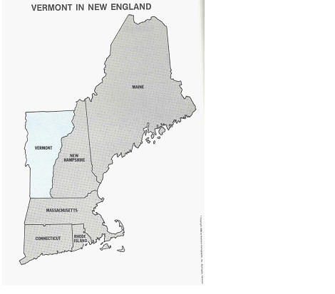
VERMONT: One of the Six New England States
|
STATE |
AREA in SQUARE MILES |
AREA RANK |
POPULATION in the Year 2000 |
POPULATION RANK |
DENSITY |
COASTLINE
(MILES) |
|
Maine |
30,920 |
1 |
1,274,923 |
3 |
41 |
228 |
|
Vermont |
9,609 |
2 |
608,827 |
6 |
66 |
- |
|
New Hampshire |
9,207 |
3 |
1,235,786 |
4 |
138 |
13 |
|
Massachusetts |
7,826 |
4 |
6,349,097 |
1 |
810 |
192 |
|
Connecticut |
4,862 |
5 |
3,405,565 |
2 |
703 |
97 |
|
Rhode Island |
1,049 |
6 |
1,048,319 |
5 |
1003 |
40 |
|
Total |
63,473 |
|
13,922,517 |
|
|
570 |
Vermont is the smallest New England State by population and second
smallest to Wyoming among
all states.
Did you know that Vermont is
the second largest New England State in area, slightly larger than New
Hampshire but also larger than Massachusetts and double the size of
Connecticut?
COUNTIES IN VERMONT
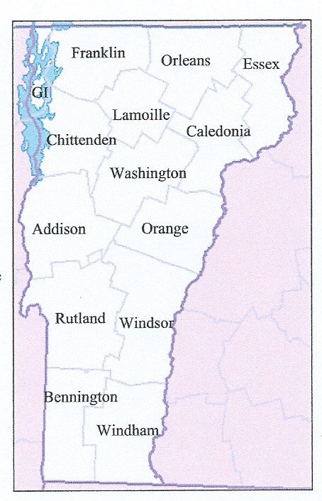
Hubbardton is in Rutland County, one of the 14 counties in Vermont.
In 1779, Vermont had two counties.The western side of the state was
called Bennington County and the eastern side was called
Cumberland County.
In 1781, Cumberland County was broken up
into three counties in Vermont plus another county named Washington
(not the same as the modern Washington County) that eventually
became part of
New Hampshire.
Today's Washington County was known as
Jefferson County
from its creation in 1810 until it was renamed in1814.
More historical detail regarding the
formation of the present day counties is found in:
http://en.wikipedia.org/wiki/List_of_counties_in_Vermont
Rutland County is second in area and
population.
|
County |
2000 Population |
Square Miles |
County Seat |
Created |
|
Addison County |
35,974 |
770 |
Middlebury |
1785 |
|
Bennington County |
36,994 |
676 |
Bennington |
1779 |
|
Caledonia County |
29,702 |
651 |
Saint Johnsbury |
1792 |
|
Chittenden County |
146,571 |
539 |
Burlington |
1787 |
|
Essex County |
6,459 |
665 |
Guildhall |
1792 |
|
Franklin County |
45,417 |
637 |
Saint Albans |
1792 |
|
Grand Isle County |
6,901 |
83 |
North Hero |
1802 |
|
Lamoille County |
23,233 |
461 |
Hyde Park |
1835 |
|
Orange County |
28,226 |
689 |
Chelsea |
1781 |
|
Orleans County |
26,277 |
697 |
Newport |
1792 |
|
Rutland County |
63,400 |
932 |
Rutland |
1781 |
|
Washington County |
58,039 |
690 |
Montpelier |
1810 |
|
Windham County |
44,216 |
789 |
Newfane |
1779 |
|
Windsor County |
57,418 |
971 |
Woodstock |
1781 |
|
Vermont Total |
608,827 |
9250 |
|
|
Above areas are land only. State
size where water area is included show the following square miles: MA is 44th with 10,555, VT is 45th with 9,615, and NH is 46th with
9,350.
For more info, see more on
Vermont Counties
and
British
Colonies.
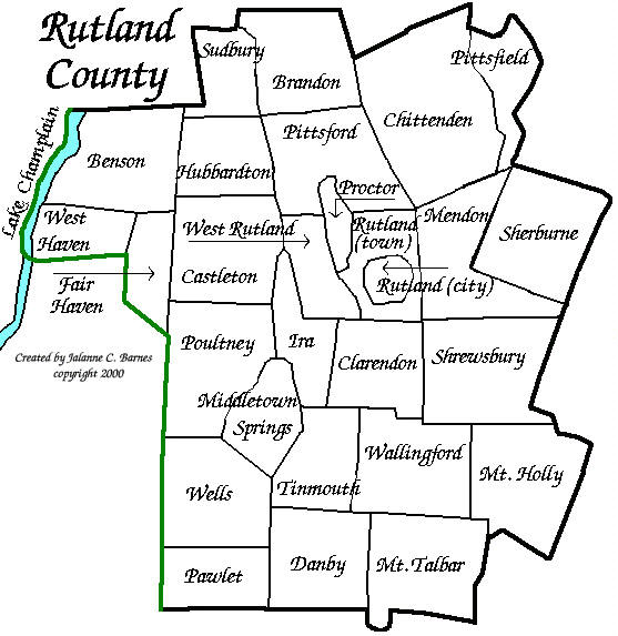
RUTLAND COUNTY
(One of 14)
NORTHEAST KINGDOM
The three counties in the northeast part of Vermont (Caledonia,
Essex, and Orleans) are referred to as the Northeast Kingdom, a term
coined by George D Aiken.
www.northlandjournal.com/stories/stories51.html George
David Aiken (August
20, 1892 – November 19, 1984) was an American farmer and politician. A
member
of the Republican
Party,
he was the 64th Governor
of Vermont (1937–1941)
before serving in the United
States Senate for
34 years, from 1941 to 1975.
“He liked being called ‘Governor’ because he liked being the governor
more than he liked being the U.S. Senate,” Mrs. Aiken explained. “It
wasn’t that he didn’t like being in the Senate, it was that he didn’t
like being away from Vermont. He never forgot that he was a Vermonter.”
And, she said he never lost touch with the average Vermonter.
Tired from weeks of work, during Senate recesses, she said it wasn’t
uncommon for him to come home to Vermont, grab his fishing pole, and
head to the Northeast Kingdom.
“The Northeast Kingdom was just one of his
favorite places in the world,” Mrs. Aiken said. “He always loved the
people up there. He used to say that many of the people didn’t have much
of anything, or have big jobs, but they were always happy. They didn’t
complain as other people would complain in the same situation. They just
made do with what they had. The people up there didn’t put on “airs” and
they always welcomed you.”
https://en.wikipedia.org/wiki/George_Aiken
The
Northeast Kingdom is bordered on the east by the
Connecticut River
and on the west by the
Green Mountains.
The highest point is
Jay Peak, a
summit on the main ridge of the Green Mountains, at 3,858 feet
(1,176 m). The highest point outside of the Green Mountains is East
Mountain in
East Haven, with
a summit elevation of 3,439 feet (1,048 m).
The area is often referred to
by Vermonters simply as "The Kingdom."
The Kingdom encompasses 55 towns and
gores, with a
land area of 2,027 square miles, about 21% of the state of Vermont.The
city of Newport is the only
incorporated city in the tri-county area.
The Northeast Kingdom has been listed in the
North American and international editions of "1,000 Places to See Before
You Die", the New York Times best-selling book by Patricia
Schultz. In 2006, the
National Geographic Society
named the Northeast Kingdom as the most desirable place to visit in the
country and the ninth most desirable place to visit in the world.
www.listology.com/openstacks/list/places-ive-been-patricia-schultzs-1000-places-see-you-die
The largest municipalities in the Northeast
Kingdom are the towns of
St. Johnsbury
(population 7,603),
Lyndon (5,981),
and
Derby (4,621),
and the city of
Newport (4,589).
Visit the oldest art galley in America
at St. Johnsbury’s Atheneum. Shop at Wiley’s General Store in
Greensboro, an establishment owned and operated by the same family for
four generations.
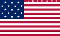
VERMONT FLAGS
Vermont was the fourteenth state to be
admitted to the union. It was admitted in 1791
The first Vermont Flag, a state militia flag, was created
in October, 1803. Vermont's first flag was created with
seventeen stripes and seventeen stars in the tradition of
the U.S. Flag. The word "VERMONT" was spelled out in upper
case letters above the stars and stripes.
Vermont went back to the drawing board and authorized a
new design on October 20, 1838. This new design continued to
align with that of the U.S. Flag. This new design reduced
the number of red and white stripes from seventeen to
thirteen. Instead of a star for each state, however, the
union contained one large white star on a blue field. Within
the confines of the star was displayed the Vermont Coat of
Arms. This flag remained as the official state flag until
1919.
Eventually Vermonters began to desire a more unique state
flag that would not be so easily confused with the flag of
the United States when hanging from a pole. As the idea for
a change became more prominent, it was found that the flag
authorized in 1838, was not ever really used to any extent
and that not many were even aware of its existence. The flag
carried by Vermont regiments in the Civil War, the Spanish
American War and at the outbreak of World War I was a flag
that displayed the Vermont State Coat of Arms on a blue
field. This design had customarily been called the
Governor's flag.
And so, in 1919, the third Vermont State Flag was
authorized. This third design displayed the Vermont State
Coat of Arms on a blue field. This is the Vermont State Flag
as we know it today.

Green Mountain Boys Flag, the militia flag of the Vermont Republic
, and the Vermont state flag from 1791 to 1804.
The second flag of Vermont used from May 1, 1804 to October 19, 1837.
On May 1, 1804, the number of U.S. states rose to seventeen, and it was
expected that the U.S. flag would change to 17 stars and 17 stripes. In
recognition, Vermont adopted what was expected to be the new U.S. flag
with the addition of the name "VERMONT" embroidered along the top. The
U.S. flag did not change in that way, resulting in the Vermont flag
having more stripes than the national flag.
The third flag of Vermont used from October 20, 1837 to May 31, 1923.
This Vermont state flag was the current U.S. flag with the multiple
stars replaced by a single large star with the Vermont coat of arms
(from the seal) within the star. The details of the star were
unspecified, and both 5-point and 8-point stars were used with 8-points
slightly more common. During the American
Civil War, the Spanish
American War, and the First
World War, the Vermont militia fought
under a banner composed of the Coat
of arms of Vermont on
a blue field.
This was essentially the same as the Vermont
Governor’s flag, and very similar to the current state flag.
Because of confusion between the striped Vermont state flag and the U.S.
flag, the design of the Vermont Governor’s flag was adopted as the
official state flag on June 1, 1923.
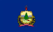
Adopted
June 1, 1923 The
Vermont state
coat of arms on
a field of azure.
"Freedom
and Unity"
is the official motto of the U.S. state of Vermont and
the African Nation of Tanzania.
The motto was first adopted in 1788 for use on the Great Seal of the
Vermont Republic. Ira
Allen designed
the Vermont seal and is often credited as its author. Following
Vermont's admission to the federal union in 1791, the legislature once
more approved the use of the motto for the new state seal.
Vermont's first governor, Thomas
Chittenden,
cited the state motto in his epitaph: "Out of storm and manifold perils
rose an enduring state, the home of freedom and unity."
US FLAG (1795 - 1818)
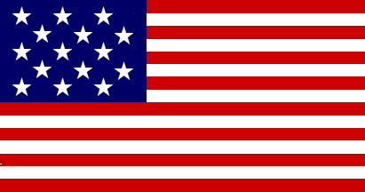 
Flew over Fort Mc Henry in Baltimore. Official Flag when
house was built in 1806 in Hubbardton (Hortonia) VT
The Star Spangled Banner: This Flag became
the Official United States Flag on May 1st,1795. Two stars were added
for the admission of
Vermont
(the 14th State on March 4th, 1791) and
Kentucky
(the 15th State on June 1st, 1792, and was to last for 23 years. The
five Presidents who served under this flag were;
George Washington (1789-1797),
John Adams (1797-1801),
Thomas Jefferson (1801-1809),
James Madison (1809-1817),
and
James Monroe (1817-1825).
The 15-star, 15-stripe flag was authorized by the Flag
Act of January 13, 1794, adding 2 stripes and 2 Stars. The regulation
went into effect on May 1, 1795. This flag was the only U.S. Flag to
have more than 13 stripes. At the time, the
practice of adding stripes (in addition to stars) with the induction of
a new state had not yet been discontinued. It was immortalized in the War of 1812
by
Francis Scott Key.
In Baltimore's preparation for an
expected attack on the city, Fort McHenry was made ready to
defend the city's harbor. When Major
George Armistead
expressed desire for a very large flag to fly over the fort,
General John S. Stricker and
Commodore Joshua Barney
placed an order with a prominent Baltimorean flagmaker for
two oversized American Flags. The larger of the two flags
would be the Great Garrison Flag, the largest battle flag
ever flown at the time. The smaller of the two flags would
be the Storm Flag, to be more durable and less prone to
fouling in inclement weather. This flag was sewn by
local flagmaker
Mary Young Pickersgill.
George Armistead,
the commander of Fort McHenry, specified "a flag so large
that the British would have no difficulty seeing it from a
distance". A replica is still flying over Fort
McHenry.
The Flag was flown over the fort
when 5,000
British
soldiers and a fleet of 19 ships attacked Baltimore on
September 12, 1814. The bombardment turned to Fort McHenry
on the evening of September 13, and continuous shelling
occurred for 25 hours under heavy rain. When the British
ships were unable to pass the fort and penetrate the harbor,
the attack was ended, and on the morning of September 14,
when the battered flag still flew above the ramparts, it was
clear that Fort McHenry remained in American hands. This
revelation was famously captured in poetry by Key, an
American lawyer and amateur poet. Being held by the British
on a truce ship in the
Patapsco River,
Key observed the battle from afar. When he saw the Garrison
Flag still flying at dawn of the morning of the 14th,
he composed a poem he originally titled Defiance of Ft.
McHenry retitled The Star-Spangled Banner, and a
portion of it would later be adopted as the United States
National Anthem. Since its arrival at the Smithsonian, the
flag has undergone multiple preservation efforts.
In
1916, President Woodrow Wilson signed an executive order
designating “The Star-Spangled Banner” as the national
anthem, and in 1931, the US Congress confirmed the decision. Although
Key wrote four verses, most people only know the first one.
SYMBOLS OF
VERMONT
|
Entered the Union: March
4, 1791 (14) |
Capital: Montpelier |
|
State Nicknames: Green
Mountain State |
State Motto: Freedom
and Unity |
|
Origin of Name: from
the French “vert mont,” meaning “green mountain” |
|
State Flower: Red
Clover |
State Bird: Hermit
Thrush |
|
State Animal: Morgan
Horse |
State Tree: Sugar
Maple |
|
State Butterfly: Monarch |
State Flavor: Maple |
|
State Insect: Honey
Bee |
State Fruit: Apple |
|
State Fish: Brook
Trout & Walleye Pike |
State Pie: Apple
Pie |
|
State Song: “These
Green Mountains" |
State Gem: Grossular
garnet |
|
National Forests: 1
• State
Parks: 52 |
|
Famous for: Ski
Resorts, Maple Syrup, Autumn Splendor |
|
Famous Vermonters: Chester
A. Arthur • Calvin Coolidge (Presidents), Orson Bean (actor),
George Dewey (admiral), John Dewey (educator), Stephen A.
Douglas (politician), Carlton Fisk (baseball), Henry Wells
(pioneer entrepreneur - Wells Fargo Co.), Rudy Vallee (band
leader) |
Many other Symbols of Vermont at:
www.en.wikipedia.org/wiki/List_of_Vermont_state_symbols and www.history.com/topics/us-states/vermont and
www.infoplease.com/us-states/vermont.html Also
see
www.netstate.com/states/symb/vt_symb.htm and
www.enchantedlearning.com/usa/states/vermont/
VERMONT'S
"TOWNS"
The state of
Vermont
has 255 political units, or "places". This includes 237
towns,
9
cities
(Burlington,
South
Burlington, Rutland, Barre, Montpelier, Winooski, St Albans, Newport
& Vergennes),
5
unincorporated areas
(Averill,
Ferdinand,
Glastenbury,
Lewis,
and
Somerset.)
and 4
gores.
(Avery’s, Buell’s, Warner’s & Warren’s).
Unincorporated
towns are those granted charters that the
Vermont legislature
later revoked due to lack
of residents. While still technically towns,
they have no local government; their affairs are managed by
a
state-appointed supervisor.
The town of
Vernon is unique as it was initially part of the grant of "Northfield" located
on both
sides of
the Connecticut River. A New Hampshire grant to
"Hinsdale" on
both sides of the
Connecticut River resulted in two Hinsdales due to a
change in the
dividing line between the colonies
of NH and MA.
This was resolved in 1753.
The
History of
Vernon is fascinating
The data below is from ancestry.com
and shows 257 “towns”.
|
Date |
Grantor |
Number |
Comment on Town |
|
1672 |
From Massachusetts, but part was re-granted in 1753
as a NH Grant |
1 |
1779 Vernon became part of Republic of VT At one
time Vernon was also called Hinsdale |
|
1749-64 |
New Hampshire Land Grants |
128 |
|
|
1769-70 |
From New York |
4 |
Royalton, Grand Isle, Bradford, Whitingham |
|
1779-91 |
Republic of Vermont |
95 |
|
|
1792 |
State of Vermont |
29 |
|
|
|
|
257 |
|
Flatlanders and Vermonters
Vermont was originally inhabited by the Abenaki and the Iroquois.
In
2005 it had an estimated population of 623,000. Vermont has the second
smallest population.
Wyoming has fewer people.) Vermont has a larger percentage of its population living
in communities
of fewer than 2,500 than any other state, so it is the most
rural.
A "Vermonter" is a
term reserved for those people actually born in Vermont. A
Flatlander is
someone
not born in Vermont, no matter how long that
person has lived in the state. Flatlanders
are also referred to as
"Turkeys". I will always be a "Buckeye", as I was born in
Ohio and I am a
legal resident of Florida.The opposite of a Flatlander
is a "Woodchuck", a term that is applied,
sometimes with negative connotations, to a native born
Vermonter.
See
http://pmillervermont.wordpress.com/2011/01/31/woodchuckery-anyone/
and also
http://stoweinnkeeper.blogspot.com/2012/03/what-it-means-to-be-vermonter.html
and also
http://www.urbandictionary.com/define.php?term=woodchuck and
http://www.heurtley.com/richard/tshov.html
and
http://www.7dvt.com/2013do-flatlander-cows-count-vermont-raised-meat
I can never be a "Vermonter", as I was not born in
Vermont. A person is a Vermonter because
his or
her mother
happened to be in Vermont on the day that person was born. Some
people
say: "Thank heavens the Flatlanders outnumber the native Vermonters."
See: http://www.freerepublic.com/focus/f-news/1005181/posts
Others say "The Road to Hell is paved
with Republicans."
Also see
http://www.heurtley.com/richard/tshov.html for some
excellent very
humorous stories.
There are appears
to be four classes of people living in Vermont: Class A .are
Vermonters that are
residents, Class B are Vermonters that are non
residents, Class C are Flatlanders that are residents,
and Class D
are Flatlanders that are non residents. Act 60 and Act 68 were
designed so that Class B
and Class D almost always pay higher property
tax rates for education in Vermont. It certainly seems
logical
that non residents should pay higher property tax rates for education.
It is surprising that
Act 68
has not been amended to provide
relief to Class B.
Vermont made national headlines in
1998. A Flatlander tried to run for Senate under the
Republican
Party, and lost. Jack McMullen, a one-year resident of Vermont, tried to
win the
Republican nomination
to run against Senator Leahy for Senate.
McMullen, the millionaire, lost
to Fred Tuttle, then a 79 year old
retired farmer. The farmer, with a 10th grade education and a
spending
budget of $201, beat the
Harvard educated McMullen, who spent $475,000
on his
campaign. In the often comical debates,
McMullen was exposed as
an outsider, a person who
didn't
know the state he was trying to win
very well. Tuttle asked him in one debate how to
pronounce the Vermont
town of Calais. McMullen answered it by pronouncing it in the French
way
(cah-lay) instead of how Vermonters say it, (cah-las).
It was clear
McMullen didn't know the state. For what reason did Tuttle win?
The simple fact that
Tuttle is a native Vermonter, and McMullen a
flatlander. McMullen tried to buy his way through the
campaign,
but
Vermonters saw through his ideas. When voting time came, Tuttle won 55%
of
the primary vote, and putting the farmer into a Senatorial race.
Tuttle's win sent a message
nationwide, Vermonters would not be bought
over by a flatlander, and would much rather have a
retired farmer in the
senate. Surprised bythe win, Tuttle laughed and lamented he would never
want to move to Washington, D.C. so he urged Vermonters to vote
for Leahy. Tuttle's job was
done, and he could go back to his farm.
(Fred
knew how many teats a cow has! McMullen didn't.
Do you?)
Also see:
http://en.wikipedia.org/wiki/Fred_Tuttle and
http://www.newenglandfilm.com/news/archives/98october/fredtuttle.htm
and
http://web.archive.org/web/20081002034033
and /http://www.vtonly.com/loresep8.htm and
http://www.chrisgraff.com/excerpt.html
SOME VERMONT FACTS See
http://www.sec.state.vt.us/kids/pubs/history_facts_fun.pdf
|
The
Green
Mountain
State
14th in union
2 U.S. Presidents
43rd largest state-9,614 square miles
65.8 people per square mile of land
1.24 million acres of farmland
78% of Vermont’s land is forest
State Animal: Morgan Horse
State Beverage: Milk State Motto: “Freedom and Unity” State Pie: Apple
State Butterfly: Monarch State Flower: Red Clover State Tree: Sugar
Maple
Montpelier, with 7,900 people, is the smallest state capital in America
It is also the only state capital in the United States without a
McDonalds
Vermont is one of four states that does not allow billboard advertising
16 awesome ski resorts, one of the largest number per state in the
country
Vermont has more covered bridges per square mile than any other state
Currently, the three most popular Ben and Jerry’s ice cream flavors are:
Cherry Garcia, Chocolate Chip Cookie Dough, Chocolate Fudge Brownie
Dairy farmers produce 300 million gallons of milk each year
Vermont is also the country’s largest producer of maple syrup
Vermont’s highest peak, Mt. Mansfield, is 4,393 ft. tall
Vermont’s 77th governor Jim Douglas
36 state
forests
52 state
parks |
TRUE VERMONTERS
| Name |
Known for |
Birthplace |
| Sherman Adams |
Governor of VT |
East Dover |
| George Aiken |
Governor of VT and US Senator from VT |
Dummerston |
| Chester Alan Arthur |
21st U.S. President |
Fairfield |
| Orson Bean |
Actor |
Burlington |
| Calvin Coolidge |
30th U.S. President |
Plymouth |
| Thomas Davenport |
Inventor |
Williamstown |
| John Deere |
Inventor of "The plow that broke the
plains" |
Rutland |
| George Dewey |
Admiral |
Montpelier |
| John Dewey , |
Philosopher and educational reformer |
Burlington |
| Stephen A. Douglas |
US Senator, elected in Illinois |
Brandon |
| James Fisk |
Financial speculator |
Bennington |
| Wilbur Fisk |
Clergyman and educator |
Guilford |
| Ralph E. Flanders |
US Senator from VT |
Barnet |
| Richard Morris Hunt |
Architect |
Brattleboro |
| William Morris Hunt |
Painter |
Bratleboro
|
| Jim Jeffords |
US Senator and US Representative from VT |
Rutland |
| Patrick Leahy |
US Senator from VT |
Montpelier |
| Justin Morrill |
US Senator from VT |
Strafford |
| Elisha Graves Otis |
Founder of Otis Elevator Company |
Halifax |
| Moses Pendleton |
Choreographer |
Lyndonville |
| Patty Sheehan |
Golfer |
Middlebury |
| Joseph Smith |
Founder of Latter Day Saint movement, |
Sharon |
| Horace A. Tabor |
Silver king |
Holland |
| Ernest Thompson |
Actor and writer |
Bellows Falls |
| Rudy Vallee |
Singer and band leader |
Island Pond |
| Henry Wells |
Pioneer and entrepreneur |
Thetford |
| William G Wilson |
Founder of Alcoholics Anonymous |
East Dorset |
| Brigham Young |
President, Church of Jesus Christ of Latter
Day Saints |
Whitingham |
FLATLANDERS
| Name |
Known for |
Birthplace |
| Ethan Allen |
Surveyor. Impetuous Leader of The Green Mountain
Boys |
Litchfield, CT |
| Ira Allen |
Surveyor. Legislator. Father of University of
Vermont |
Cornwall, CT |
| Thomas Chittenden |
Governor of the Republic of VT and then the State of
VT |
East Guilford, CT |
| Howard Dean |
Physician. Governor of VT |
East Hampton, NY
|
| Robert Frost |
Poet who lived in NH and in VT |
San Francisco, CA
|
| Hetty Green |
Witch of Wall Street. The wealthiest woman in the
world |
New Bedford,MA |
| Madeleine M Kunin |
Diplomat and politician. Governor of VT |
Zurich, Swiss |
| Bernie Sanders |
US Senator from VT |
Brooklyn, NY
|
| John Stark |
Major General in Continental Army and Hero of
Bennington "There are your enemies, the Red Coats and the Tories. They are ours,
or this night Molly Stark sleeps a widow!" and a quote from a
July 31, 1809 letter that 81 year old Stark wrote to decline an
invitation to an anniversary reunion of the
Battle of Bennington:
"Live free or die: Death is not the worst of evils."
|
Londonderry, NH |
| Seth Warner |
Colonel in Continental Army.
Rear Guard Commander at Hubbardton |
Roxbury, CT |
| Benning Wentworth |
King
George II's Royal Governor of New Hampshire |
Portsmouth, NH |
WINDSOR
Windsor I n
1777, the signers of the Constitution
of the Vermont Republic met
at Old
Constitution House,
a tavern at the time, to declare independence from the British Empire
(the Vermont
Republic would
not become a state until 1791). In 1820, it was the state's largest
town, a thriving center for trade and agriculture.
The community is named for Windsor, Connecticut.
It
is known as the birthplace of Vermont, where the state constitution was
signed, and acted as the first capital until 1805 when Montpelier became
the official state capital.
MONTPELIER
Montpelier was
not always the capital of Vermont. At first, the Vermont General
Assembly met only once every two years. Many of the first meetings were
held in Windsor, Bennington, Rutland, and other towns.
The first permanent settlement began in May 1787,
when Colonel Jacob Davis and General Parley Davis arrived from
Charlton, Massachusetts.
General Davis surveyed the land, while Colonel Davis cleared forest and
erected a large log house on the west side of the North Branch of the
Winooski River.
It was Colonel Davis who selected the name
Montpelier after the
French city
Montpellier.There
was a general enthusiasm for things French as a result of the country's
aid during the
American Revolution.
Montpelier is situated on the Winooski River in the central part of the
state. It is the smallest population of any capital city in the United
States.
The population was 7,855 at the 2010
census.
Montpelier was chosen to become the permanent state capital in 1805,
after some strenuous debate, due to its central location.
When the time came to build a new capitol in
1831, the citizens of Montpelier pledged $15,000 to support its
construction, preventing the state government from being transferred to
any of the other five competing cities.
When the second capitol burned
down in 1857, there was considerable support for moving the capital to Burlington,
but Montpelier carried the day. The third Vermont Statehouse, which
still stands, was 25 percent larger than the one it replaced, but still
modest by the standards of other states.
 .png)
"Montpelier" can be translated to be "bare hill".
The hill behind the capitol building was bare of trees.
MAJOR CITIES
Based on the 2010 census, 115,085 people resided
in Vermont's cities, or 18.39% of the state's population. The
state of
Vermont has 255
political units,
or "places". Of these, the nine listed below are incorporated as
cities, and considered municipalities independent of the surrounding
town(s) and county(s).
Here is another list:
|
Rank |
City |
Population |
|
Rank |
City |
Population |
| 1 |
Burlington
|
42,211 |
|
26 |
Rockingham |
5,140 |
| 2 |
Essex |
20,724 |
|
27 |
Waterbury Town |
5,098 |
| 3 |
South Burlington |
18,743 |
|
28 |
Jericho |
5,074 |
| 4 |
Colchester |
17,384 |
|
29 |
Randolph |
4,755 |
| 5 |
Rutland City
|
15,942 |
|
30 |
Georgia |
4,684 |
| 6 |
Bennington
|
15,431 |
|
31 |
Castleton |
4,612 |
| 7 |
Brattleboro
|
11,765 |
|
32 |
Fairfax |
4,524 |
| 8 |
Milton |
10,667 |
|
33 |
Derby |
4,502 |
| 9 |
Essex Junction |
9,881 |
|
34 |
Hinesburg |
4,497 |
| 10 |
Hartford |
9,829 |
|
35 |
Newport City |
4,473 |
| 11 |
Springfield
|
9,232 |
|
36 |
Stowe |
4,411 |
| 12 |
Williston |
9,215 |
|
37 |
Manchester Town |
4,313 |
| 13 |
Barre City |
8,837 |
|
38 |
Richmond |
4,129 |
| 14 |
Middlebury
|
8,545 |
|
39 |
Rutland Town |
4,019 |
| 15 |
Barre Town
|
7,857 |
|
40 |
Bristol |
3,918 |
| 16 |
Shelburne
|
7,736 |
|
41 |
Brandon |
3,860 |
| 17 |
Montpelier
|
7,671 |
|
42 |
Charlotte |
3,856 |
| 18 |
St. Johnsbury
|
7,523 |
|
43 |
Cambridge Town |
3,748 |
| 19 |
Winooski |
7,228 |
|
44 |
Highgate |
3,608 |
| 20 |
St. Albans City |
6,860 |
|
45 |
Shaftsbury |
3,531 |
| 21 |
Swanton Town |
6,442 |
|
46 |
Johnson Town |
3,511 |
| 22 |
St. Albans Town |
6,313 |
|
47 |
Pownal
and
Windsor
|
3,476 |
| 23 |
Northfield Town |
6,114 |
|
48 |
Norwich |
3,386 |
| 24 |
Lyndon |
5,941 |
|
49 |
Williamstown |
3,383 |
| 25 |
Morristown |
5,389 |
|
50 |
Hartland |
3,379 |
|
About 25% of Vermont's population reside in Chittenden County.
BURLINGTON
Burlington is the largest city in Vermont.
The city is the hub of the Burlington-South
Burlington metropolitan
area,
consisting of the three northwestern Vermont counties of Chittenden, Franklin and Grand
Isle and
encompassing the cities of Burlington, South
Burlington,
and Winooski;
the towns of
Colchester, Essex,
and Williston;
and the village of Essex
Junction.
According to the 2012 U.S.
Census estimates,
the metro area had an estimated population of 213,701, approximately one
third of Vermont's total population.
One of the New
Hampshire grants,
the land that was developed as Burlington was awarded by Governor Benning
Wentworth on
June 7, 1763 to Samuel Willis and 63 others.
The town was organized in
1785. The town's position on Lake
Champlain helped
it develop into a port
of entry and
center for trade, particularly after completion of the Champlain
Canal in
1823, the Erie
Canal in
1825, and the Chambly
Canal in
1843.
Read about Lilian Baker
Carlisle.
Photogallery\Lilian
Baker Carlisle.docx
RUTLAND
The town was originally granted in 1761 by
Governor
Benning Wentworth
as one of the
New Hampshire Grants.
He named it after
John Manners, 3rd Duke of Rutland.
The Original Town of Rutland was chartered in 1761 and was later divided
into; the Town of Proctor, the Town of West Rutland and the City of
Rutland. T
The first settlers arrived in 1770 led by Colonel James Mead.
James Meade, Rutland's first
settler arrived in Center Rutland in 1769. . The next year,
he and his family were given shelter by members of the Caughnawag Tribe
while they finished their log cabin. Meade built saw and gristmills on
the falls (Meade's Falls) and ran a ferry on the Otter Creek. He was an
ardent defender of the New Hampshire Grants and served as a Colonel in
the militia. Mead's falls was an important military site. The 1759 Crown
Point Military Road ran by here. General Arthur St. Clair wrote his
report after the Battle of Hubbardton in 1777 at Mead's home on the West
Proctor Road.
Fort Ranger was built in 1778 on the bluff
northeast of the falls. The
first commander was Captain Gideon Brownson. During the
American Revolutionary war
Whitcomb's Rangers
were stationed there. Whitcomb's Rangers
were authorized on October 15, 1776, and formed in November 1776 at
Fort Ticonderoga
in
New York. The
unit consisted of two companies of
New Hampshire
rangers for
service with the
Continental Army
under the command of
Benjamin Whitcomb,
a veteran of
Bedel's Regiment.
They saw action at the
Battle of Hubbardton,
Battle of Bennington
and the
Battle of Saratoga.
They were disbanded on January 1, 1781 at
Coos, New Hampshire.
During the early 1800’s the Rutland area was known for agriculture and
for the sheep industry. By the mid 1800’s the development of the marble
industry and the arrival of the railroads created an industrial and
retail boom which brought many immigrant workers to the Rutland area.
Rutland has continued to grow in industry and population to become the
largest city in Southern Vermont.
Fort Rutland (above) (1775-1775) - A small
stockaded
Revolutionary War
Fort established in 1775 in present day Rutland in Rutland County,
Vermont. One small building used for storage of ammunition and
supplies inside the stockade. Abandoned in 1775. Located at the park in
downtown Rutland on the SW corner of Rt 7 and West Street. There
is a stone site marker at the intersection of Terrill ST. and North Main
St. in Rutland.
OTHER FORTS IN VERMONT See
http://www.northamericanforts.com/East/vt.html
Fort Warren After the loss
of Fort Ticonderoga and Mount Independence in July 1777, Fort Warren was
built and became a part of a string of forts built across the state for
the defense of Vermont. It was located in Castleton from 1777 to 1779.
Fort Warren was located one-half
mile east of Castleton village, on a natural plateau, with an area of
less than three acres. This plateau is about fifteen feet higher than
the surrounding meadow in a bend on the north side of Bird's Creek, or
Castleton River, and immediately north of the highway leading through
Castleton to Rutland, about twenty rods west of the mouth of Mead's
Brook, now commonly called Hubbardton Brook. This plateau was connected
with a plain to the north, of many acres in extent, by a narrow neck of
land on the same level. When the Rutland and Washington Railroad was
being built in 1850 this neck of land was dug away to make the dump
across the meadow west. A strip of this plateau, thirty or forty feet
wide on the north side, and about one-half of the west end of it, were
also dug away, for the same purpose, to the depth of eight or ten feet.
On the north side of the railroad, and parallel with it, a new channel
was cut by the company, at the same time, and Hubbardton Brook was
turned into it, which saved building a railroad bridge across the old
channel, but necessitated building a bridge for the public travel across
the new channel in line of the Hubbardton Road, which crossed the old
fort ground. The general features of this old landmark have thus been
materially changed; only about one-half of the original plateau, at the
east end, is now left as it was in the Revolutionary period.
The
fort was built on land owned by George FOOT on the east and Peter
COGSWELL on the west. The stockade enclosed the dwellings of both these
men. The entire ground is now owned by John J. LANGDON, and his
dwelling-house stands near the eastern boundary of the stockade.
VERMONT ROADS
See History
of Roads. Also see
www.vtroads.com/vtr_trailsetc.htm
The first roads in Vermont were Military Roads. In 1759,
the British constructed Vermont's first interstate highway, the Crown Point
Road. It was built during the French and Indian War when General
Jeffrey Amherst, wished to continue his campaign into Canada. Native Americans
had followed the waterways leading from Canada to the coast. One of the
most-traveled routes connected Lake Champlain and the Connecticut River
following Otter Creek and the Black River. This footpath led from Amherst’s
strategic position at Crown Point, New York directly to an important military
post, Fort No. 4 on the Connecticut River.
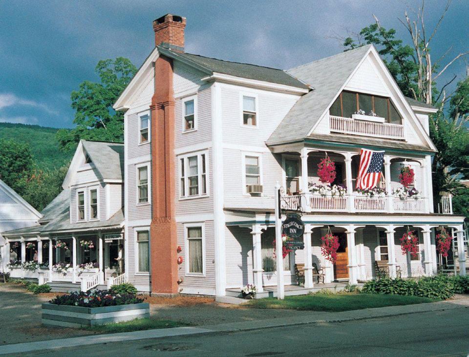
STAGECOACHES (in Castleton, Sudbury, Hubbardton and
other)
The Hubbardton Turnpike Company was
chartered on November 11, 1802. It allowed immigrants to go north from
Castleton to Sudbury. The turnpike continued in business until November
1851 when its charter was repealed. This became the present Route 30,
and went past the Hyde Manor property in Sudbury and along the east side
of Lake Bomoseen and Beebe Pond in Hubbardton. Prior to the building of
this turnpike, the only north south road along Beebe Pond was a
stagecoach road along the west side of Beebe Pond.
|
The Old Inn in Sudbury. It served as a stage coach
stop and hotel through the 1850's.
It was located on
the northeast corner of Rt 30 and Rt 73.
It was also known as
Sawyer’s Stand” |
 |
 |
Between 1830 and 1845 Dewey's Stand in Hubbardton was a stage coach
stop. Read about Joel Beaman of Poultney, Ebenezer B Dewey of Hubbardton
and Castleton, and Arunah Hyde of Castleton in
Stagecoach History.
The term
"stage" originally referred to the distance between stations on a route,
the coach traveling the entire route in "stages," but through metonymy
it came to apply to the coach. A fresh set of horses would be staged at
the next station, so the coach could continue after a quick stop to
rehitch the new horse team. Under this staging system, the resting,
watering and feeding of the spent horses would not delay the coach.
 |
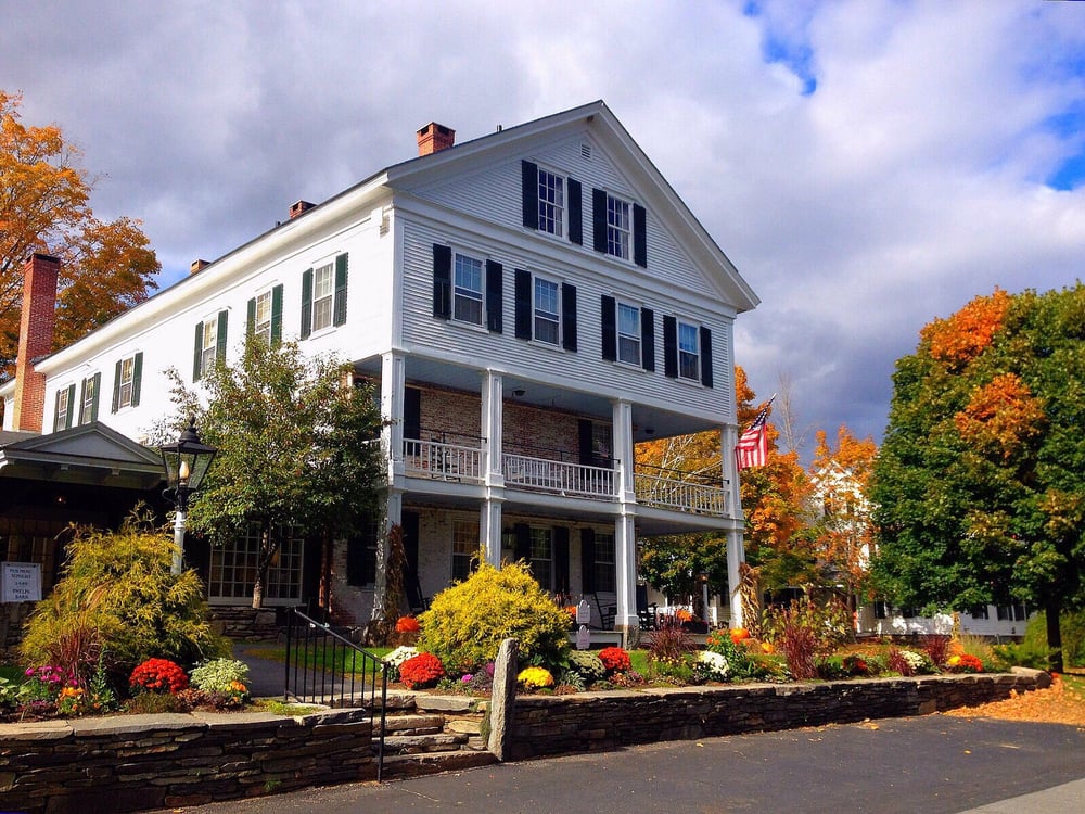
Hezekiah Barnes built
Stagecoach Inn in
Charlotte
in 1783. Barnes had moved with his family to Charlotte
in 1780, and established the inn and a
trading post
on opposite sides of the main stage route from
Montreal
to southern
New England.
Town residents referred to as the Tavern Stand.
It was dismantled and rebuilt at the Shelburne Museum in
1949. |
|
Old Stagecoach Inn in Waterbury.
The inn
was built in 1826. The inn, or tavern, served as a
rest stop for people and horses and as a local meeting house. The
railroad across the state had not yet been built, so travel in both
directions was by horse-drawn coach over rutted roads, icy and snow
covered in winter, and a bottomless sea of mud in the spring. At that
time, Main Street (now Route 2) was known as the Winooski Toll Road, a
forerunner of revenue raising practices to come. In 1848 the railroad
came through, so that stage coach travel survived only in the
north/south direction.
http://www.oldstagecoach.com/site/page/history |
 |
 |
Averill Stand in Wilmington was built in 1787 and was
for many years the stagecoach stop between Bennington and
Brattleboro on what is now Route 9. The Averill family
managed the stagecoach stand on the site hence the name
Averill Stand as well as the tavern and Inn. |
| The Henry Farm Inn, in Chester
is a center hall Federal built in the late 1700's, is located
on the Green Mountain Turnpike. Our well-maintained two hundred year old
farmhouse was the first tavern in Chester, when it served as a
stagecoach stop on the Green Mountain Turnpike. In colonial times
this turnpike ran from Boston to Montreal, but now is a quiet,
picturesque dirt road |
 |
The Norwich Inn
is a historic, full-service Vermont country inn located in Norwich, near
Dartmouth College, just across the river from Hanover, New Hampshire. An Inn has
been on the Main Street site since 1797; the current Victorian Structure since
1890. . Built by Colonel Jasper Murdock in 1797, the historic Norwich Inn served
as a stagecoach tavern and hostelry for generations of New England travelers.
Known variously as the Norwich Hotel, Curtis Hotel, The Union House, and the
Newton Inn. Local legend has it that the Inn and the Town were the
inspiration behind the popular TV Show, “Newhart,” which was set in Norwich.
Pictures below from
www.norwichinn.com/historic-vermont-inns.php
 
  
| Ye Olde Tavern in Manchester claims to be the oldest inn in
Vermont. Built by Dorset, Vermont master builder Aaron Sheldon. It
dates back to 1790 when it was known as the Stage coach Inn.
It later was known as Lockwood's Tavern. The marble porch was
added in 1850. In 1860, Steven Thayer purchased the inn and
was known as "Thayer's Hotel". In 1902, it was the Fairview Hotel and
the tavern became headquarters for the movement to license the sale of
"spirituous beverages". Two years later, revocation of the license
closed the hotel. After the installation of electricity in 1924, Walter
Clemons-McGuire re-opened the tavern as a hotel and antique shop.
It’s on the Vermont Register of Historic Places.
http://yeoldetavern.net/our_story.php |
 |
 |
The Grafton Inn
in Grafton is one of the oldest operating inns in America.
It opened
its doors in 1801when Enos Lovell, converted his two-story private
home into an inn in 1801.
The
Grafton Inn is the center of town activity.
It has
welcomed luminaries like Ralph Waldo Emerson, Rudyard Kipling, Daniel
Webster, Theodore Roosevelt and Woodrow Wilson. |
Was the Grafton
Inn and other Inns ... stagecoach
stops?
|
n 1796, The Dorset Inn in Dorset welcomed
its first guests - travelers en route to the major markets in Boston and
Albany. After tethering their horses at the Inn's front door, they would
pass an evening before the fireplace of the Inn, eat a hearty supper and
retire to the four poster bed.
http://dorsetvthistory.org/history.html It
was first first called the Washington Hotel.
The Dorset Inn, shown below when it was
photographed in 1895.
|
 |
archive.burlingtonfreepress.com/article/20130309/LIVING20/303090003/The-Dorset-Inn-has-stood-the-test-of-time-since-1796
In New York we
find:
http://stagecoachdays.blogspot.com/2011/12/existing-inns-and-taverns.html
VERMONT IS ONE OF THE 13 STATES THAT SHARES A BORDER WITH CANADA
Vermont shares a national border of 90 miles with Quebec,
Canada.
Montreal, Canada's 2nd largest city is only
75 miles from Burlington, Vermont.
Originally calledVille-Marie,
or "City of Mary", it
is named after Mount
Royal, the
triple-peaked hill in the heart of the city. The city is on the
Island of Montreal,
In 2011 the city had a population of 1,649,519. Current estimates place the
metropolitan area of Montreal at 4.1 million.
|
| 67 |
Fair Haven |
2,650 |
| 68 |
East Montpelier |
2,626 |
| 69 |
Vergennes |
2,597 |
| 70 |
Thetford |
2,591 |
| 71 |
Clarendon |
2,504 |
| 72 |
Swanton Village |
2,374 |
| 73 |
Richford |
2,316 |
| 74 |
Arlington |
2,277 |
| 75 |
West Rutland |
2,246 |
| 76 |
Sheldon |
2,230 |
| 77 |
Danville |
2,208 |
| 78 |
Newbury Town |
2,202 |
| 79 |
Vernon |
2,184 |
| 80 |
Guilford |
2,093 |
| 81 |
Westford |
2,085 |
| 82 |
Grand Isle |
2,081 |
| 83 |
Northfield Village |
2,057 |
| 84 |
Monkton |
2,047 |
| 85 |
Wallingford |
2,041 |
| 86 |
Newport Town |
2,034 |
| 87 |
Morrisville |
2,031 |
| 88 |
Bethel |
2,016 |
| 89 |
Alburgh Town |
2,008 |
| 90 |
Dorset |
1,996 |
| 91 |
Huntington |
1,986 |
| 92 |
Ludlow Town |
1,935 |
| 93 |
Fairfield |
1,911 |
| 94 |
Wilmington |
1,842 |
| 95 |
Dummerston |
1,829 |
| 96 |
Waterbury Village |
1,801 |
| 97 |
Starksboro |
1,774 |
| 98 |
Londonderry and
Middlesex |
1,756 |
| 99 |
New Haven |
1,741 |
| 100 |
Burke |
1,735 |
| 101 |
Waitsfield |
1,723 |
| 102 |
Wolcott |
1,721 |
| 103 |
Berkshire |
1,716 |
| 104 |
Warren |
1,703 |
| 105 |
Newfane Town |
1,684 |
| 106 |
Barnet |
1,683 |
| 107 |
Proctor |
1,677 |
| 108 |
Moretown |
1,664 |
| 109 |
South Hero |
1,627 |
| 110 |
Troy and North Bennington |
1,622 |
| 111 |
Calais |
1,600 |
| 112 |
Poultney Village |
1,579 |
| 113 |
Marshfield Town |
1,550 |
| 114 |
Sharon |
1,495 |
| 115 |
Cabot |
1,449 |
| 116 |
Johnson Village |
1,444 |
| 117 |
Pawlet |
1,438 |
| 118 |
Franklin |
1,424 |
| 119 |
Corinth |
1,366 |
| 120 |
Addison |
1,365 |
| 121 |
Cavendish |
1,361 |
| 122 |
Bakersfield |
1,351 |
| 123 |
Eden |
1,348 |
| 124 |
Fayston |
1,347 |
| 125 |
Whitingham |
1,344 |
| 126 |
Duxbury |
1,337 |
| 127 |
Enosburg Falls and Fletcher |
1,314 |
| 128 |
Brookfield |
1,289 |
| 129 |
Danby |
1,287 |
| 130 |
Tunbridge |
1,286 |
| 131 |
Waterford |
1,280 |
| 132 |
Shoreham and Lincoln |
1,272 |
| 133 |
Lunenburg |
1,270 |
| 134 |
Plainfield |
1,252 |
| 135 |
Orwell |
1,250 |
| 136 |
Chelsea |
1,245 |
| 137 |
Chittenden |
1,237 |
| 138 |
Braintree |
1,231 |
| 139 |
Mount Holly |
1,222 |
| 140 |
Bridport |
1,221 |
| 141 |
Townshend |
1,217 |
| 142 |
Concord |
1,203 |
| 143 |
Lyndonville |
1,199 |
| 144 |
Montgomery |
1,195 |
| 145 |
Bolton |
1,191 |
| 146 |
Cornwall |
1,189 |
| 147 |
Brighton |
1,182 |
| 148 |
Craftsbury |
1,179 |
| 149 |
Topsham |
1,171 |
| 150 |
Ryegate |
1,148 |
| 151 |
Irasburg |
1,138 |
| 152 |
Wells |
1,137 |
| 153 |
Salisbury |
1,131 |
| 154 |
Rochester |
1,121 |
| 155 |
Leicester |
1,119 |
| 156 |
Dover |
1,108 |
| 157 |
Strafford |
1,107 |
| 158 |
Glover |
1,099 |
| 159 |
West Windsor |
1,089 |
| 160 |
Orange |
1,073 |
| 161 |
Marlboro |
1,067 |
| 162 |
Coventry |
1,059 |
| 163 |
Mendon |
1,038 |
| 164 |
Benson |
1,037 |
| 165 |
Shrewsbury |
1,033 |
| 166 |
Washington |
1,029 |
| 167 |
Jamaica |
1,022 |
| 168 |
Sutton |
1,019 |
| 169 |
Groton |
1,013 |
| 170 |
Charleston |
1,001 |
| 171 |
Worcester |
992 |
| 172 |
Fairlee |
987 |
| 173 |
Brownington |
969 |
| 174 |
Sunderland |
951 |
| 175 |
Canaan |
934 |
| 176 |
Walden |
933 |
| 177 |
Barnard |
931 |
| 178 |
Bridgewater |
930 |
| 179 |
Albany Town |
920 |
| 180 |
Woodbury |
895 |
| 181 |
Pomfret |
894 |
| 182 |
Wardsboro |
886 |
| 183 |
Woodstock Village |
879 |
| 184 |
Elmore |
872 |
| 185 |
Lowell |
861 |
| 186 |
Weybridge |
828 |
| 187 |
Stamford |
818 |
| 188 |
Wheelock |
806 |
| 189 |
North Hero |
805 |
| 190 |
Killington and Ludlow Village |
795 |
| 191 |
Orleans |
787 |
| 192 |
Winhall |
759 |
| 193 |
Jeffersonville |
747 |
| 194 |
Greensboro |
746 |
| 195 |
Morgan and Readsboro |
742 |
| 196 |
Peacham |
735 |
| 197 |
Middletown Springs |
732 |
| 198 |
Stockbridge |
731 |
| 199 |
Manchester Village |
728 |
| 200 |
Halifax |
723 |
| 201 |
Vershire |
722 |
| 202 |
Barton Village and St. George |
708 |
| 203 |
Rupert |
700 |
| 204 |
Sheffield |
699 |
| 205 |
Hubbardton |
693 |
| 206 |
Roxbury and Waterville |
687 |
| 207 |
Panton |
675 |
| 208 |
Grafton |
670 |
| 209 |
West Fairlee |
657 |
| 210 |
Reading and Derby Line |
656 |
| 211 |
Holland |
617 |
| 212 |
Plymouth |
616 |
| 213 |
Tinmouth |
614 |
| 214 |
North Troy |
600 |
| 215 |
Ripton |
595 |
| 216 |
Newark |
581 |
| 217 |
Derby Center |
580 |
| 218 |
Weston |
561 |
| 219 |
Saxtons River |
555 |
| 220 |
Jay |
552 |
| 221 |
Sudbury |
548 |
| 222 |
Pittsfield |
543 |
| 223 |
Westfield and Brookline |
524 |
| 224 |
Kirby and Alburgh Village |
499 |
| 225 |
Hyde Park Village |
491 |
| 226 |
Andover and Waltham |
477 |
| 227 |
Isle La Motte |
473 |
| 228 |
Athens |
437 |
| 229 |
Ira |
428 |
| 230 |
Whiting |
424 |
| 231 |
Windham |
416 |
| 232 |
Woodford |
413 |
| 233 |
Sandgate |
398 |
| 234 |
Wells River |
394 |
| 235 |
Peru |
365 |
| 236 |
Newbury Village |
362 |
| 237 |
Belvidere |
355 |
| 238 |
Westmore |
342 |
| 239 |
West Burke |
338 |
| 240 |
Hancock |
326 |
| 241 |
Granville |
301 |
| 242 |
East Haven and Westminster Village |
285 |
| 243 |
Marshfield Village |
265 |
| 244 |
West Haven |
259 |
| 245 |
Mount Tabor |
256 |
| 246 |
Baltimore and Guildhall |
255 |
| 247 |
Cambridge Village |
236 |
| 248 |
Stannard |
222 |
| 249 |
Jacksonville |
220 |
| 250 |
Bloomfield |
215 |
| 251 |
Stratton |
212 |
| 252 |
Maidstone |
202 |
| 253 |
Albany Village |
187 |
| 254 |
Goshen |
163 |
| 255 |
Landgrove and Norton |
160 |
| 256 |
Old Bennington |
138 |
| 257 |
Perkinsville |
128 |
| 258 |
Newfane Village |
116 |
| 259 |
Brunswick |
115 |
| 260 |
Searsburg |
107 |
| 261 |
Lemington |
101 |
| 262 |
Granby |
85 |
| 263 |
Victory |
60 |
|
|
|
|
Home | Vermont Sightseeing | Vermont: Fauna & Flora | Vermont Lakes & Rivers | Vermont Mountains & Hiking | Vermont History | Vermont Beebe Pond & Hubbardton | Vermont Properties |
|

