AUDUBON'S CORKSCREW SWAMP SANCTUARY
(Northeast of Naples, FL off Immokolee Road)
Directions
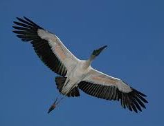
At one time, the sanctuary's bald cypress forest
supported an estimated 100,000 Wood Storks.
Be sure to walk the 2.25 mile boardwalk loop. Wood Storks are very beautiful
in flight, but their faces can stop a clock.

Maps of the FT Myers and Naples Areas
See
one map.
See two maps.
Sightseeing Ideas from Naples
Click here.
Take a ride on the Naples Water Taxi:
The Blue Pelican
NORTH OF NAPLES
Bonita Springs (abuts Naples to the north)
Everglades Wonder Gardens The 3.5 acre botanical
jungle was created by Bill and Lester Piper in 1936 to rehabilitate injured
animals. It is of historical interest, but a bit tired.
www.evergladeswondergardens.com
Read about the park. See
slide show.
Imperial River Go
canoeing. 239-533-7444 See
www.kayakroutes.com/imperial_river.html
and
www.floridarambler.com/florida-canoeing-kayaking-paddling/imperial-river-kayak-trail-bonita-springs/
and
www.youtube.com/watch?v=s0u92HNxJz8 At River Park,
239-992-2556, walk a boardwalk. See
www.lifeinbonitasprings.com/blog/river-park-at-imperial-river-bonita-springs-florida/
Read about
Ghost Tours.
Mound Key Archaelogical State Park
(in Estero) It is a man made island, accessible only by boat.
Believed to have been the capital of the Calusa. 239-992-0311
www.en.wikipedia.org/wiki/Mound_Key_Archaeological_State_Park and
www.floridastateparks.org/park/mound-key
Lover's Key
(Between Bonita Springs and Ft Myers) Visit
Lover's Key
Also see
www.loverskeyadventures.com
Ft Myers: Be sure to visit the
Edison Home and the Ford Home:
www.en.wikipedia.org/wiki/Edison_and_Ford_Winter_Estates and
www.edisonfordwinterestates.org Near Ft Myers is Sanibel Island
which contains the "J N Ding Darling National Wildlife
Refuge". See
www.fws.gov/refuge/jn_ding_darling/
The Great Calusa Blueway is a
"Paddling Trail" in Lee County. See
www.calusablueway.com and
See
http://www.floridarambler.com/florida-canoeing-kayaking-paddling/calusa-blueway-best-florida-kayak-trail/
Okeechobee Waterway
The name Okeechobee comes from the Hitchiti words oki
(water) and chubi (big). It is the 7th largest freshwater lake in the
US. The waterway is 154 miles long and stretches from the Atlantic Ocean
near Stuart, Florida to the Gulf of Mexico at Fort Myers. It is the only
true cross Florida canal and river system that joins the east coast of
Florida to the west coast. The eastern reach of the waterway starts at
Stuart in the St. Lucie River, passes through the St Lucie lock and dam, and
enters Lake Okeechobee through a lock at Port Mayaca. From Port Mayaca
you cross the 451,000 acre lake. The waterway continues west on the
Caloosahatchee River to Fort Myers. Read about this at
www.offshoreblue.com/cruising/okeechobee.php Lake
Okeechobee is higher than the ocean.
There are five locks on the Okeechobee Waterway
to raise boats from sea level to the level of the lake.
From Stuart east to the lake, the locks are: the St Lucie
Lock and the Port Mayaca Lock. From the lake west to the Gulf, they are the
Moore Haven Lock, the Ortona Lock, and the W. P. Franklin Lock.
See
www.offshoreblue.com/cruising/okeechobee-locks.php

Read about the St Lucie River and the St
Lucie Canal
at
www.sfwmd.gov/portal/page/portal/xrepository/sfwmd_repository_pdf/stlucie.pdf
and the Caloosahatchee River and the Caloosahatchee Canal at
www.protectingourwater.org/watersheds/map/caloosahatchee/ "Hatchee"
means "river". Listen to the song Roll on Caloosahatchee at
www.reverbnation.com/mikejurgensen/song/5131260-roll-on-caloosahatchee?fb_og_action=reverbnation_fb:unknown&fb_og_object=reverbnation_fb:song&utm_campaign=a_public_songs&utm_con
Sarasota: Be sure to visit the Ringling Art Museum:
www.ringling.org and the
Ringling Home:
www.ringling.org/ca-dzan . If time, try to visit the Ringling Circus
Museum:
www.ringling.org/circus-museum There is also much more to learn
about the Ringlings in the
Burton Genealogy. When in Sarasota visit Selby Gardens:
http://selby.org/the-gardens/ The Myakka River State Park,
9 miles east of I-75 near Sarasota is worth visiting. Take a boat ride
on Lake Myakka. See
www.floridastateparks.org/park/Myakka-River
MARCO ISLAND (Just south of
Naples)
Read about the history at
www.paradisecoast.com/articles/marco_island_history and at www.marcoisland.org/history.htm
and at
www.marco-island-florida.com/history.htm
and at
www.marcosun.com/marco_history.htm and about the
Key Marco Cat at
www.keymarcocat.com/history.html
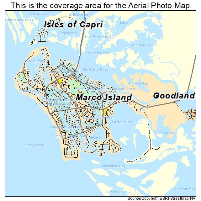
GOODLAND (a village in the
SE corner of Marco Island www.goodland.com)
Annual Mullet
Festival
is held every January. The
three-day festival attracts nearly 5,000 people to Goodland. Fried and
smoked mullet are featured and in addition to the Buzzard Lope Queen event
there is also a Buzzard Lope Princess day when girls from ages 6 to 16
compete for the title, a trophy and cash prizes. See
www.goodland.com/buzzard.htm
Stan's Idle Hour Bar. See
www.goodland.com/stan.htm
and
www.stansidlehour.net and
www.stansidlehour.net/Photo_Gallery.html and
www.stansidlehour.net/TheBuzzardLope.html and
www.stansidlehour.net/Entertainment.html Stan Gober
Memorial Bridge: On January 29, 2015, at the northern end of the County
Road 92 bridge, a crowd assembled to rechristen the span, formerly called
the Goodland Bridge over the Marco River, as the Stan Gober Memorial Bridge
after Stan, the larger-than-life founder and owner of Stan's Idle Hour in
Goodland.. See
slide
show at Stan's on February 15, 2015.
Consider
visiting Stan�s Idle Hour at 1pm on Sundays.
Buzzard Lope Dance was similar
to the more modern
Eagle Rock Dance and
was very popular in the South. The
Lope most likely is related to the older West African Buzzard dance. Sunbury
Georgia was the first discovery of this dance but may not have originated
there. The Buzzard Lope used outstretched arms like a bird and consisted of
a shuffle step and a little buzzard like hop. The dance is said to be
similar to the West African Buzzard Dance. The original form was
representing a Turkey Buzzard circling, then getting ready to eat a dead
Mule (some report a Cow or Carrion in general). Many people in the
sidelines watching the dance would do a 'Patting', or make a rhythm by
slapping their thighs, while someone would sing the cues. The Eagle Rock
replaced the Buzzard Lope in popularity as the buzzard lope was considered
too risque as well as to the connection of Plantation life by city folk. See
www.youtube.com/watch?v=nqpaw4qJjcI and
www.youtube.com/watch?v=3dGamWaYcLg
EAST & SOUTH OF NAPLES & MARCO
Read about Everglades City at
www.en.wikipedia.org/wiki/Everglades_City,_Florida
It is at the mouth of the Barron River, on Chokoloskee
Bay. The river was called Potato Creek and then renamed Allen River
after William Smith Allen the first permanent settler. The Allen River was
later renamed the Barron River after Barron Collier.
Read about Baron Collier at
www.en.wikipedia.org/wiki/Barron_Collier
Read
about Barron Collier's
Rod and Gun Club in Everglades City.
Read about the
Tamiami Trail.
State
Rt 29. State
Road 29 was extended from Immokalee to Everglades City in the 1920s around
the same time as the construction of the
Tamiami Trail. Its
construction was championed by
Barron Collier as a
land connection to
Everglades City (the
county seat of
Collier County
at the time).[2]
The route was designated State Road 164 until 1945, when it was changed to
State Road 29 as part of a
state-wide renumbering.
State Road 29 was extended from Everglades
City to Chokoloskee in 1956 upon the completion of a
causeway across
Chokoloskee Bay. South of Immokalee, SR 29 mostly runs along the former
route of the
Atlantic Coast Line Railroad's
route from Harrisburg (just south of
Palmdale)
to Everglades City, which was also built in the 1920s. The line was removed
from Sunniland south to Everglades City in 1957, and the rest of it was
removed in the 1980s.
Before the
Florida Department of Transportation
removed a large number of
State Roads from its
list for state control and maintenance, SR 29 continued south through the
towns of
Jerome,
Copeland, and then
meeting
Everglades City just
outside the
Everglades National Park.
Now designated County Road 29 north of Everglades City and County Road 29A
south of it, the historic southern terminus of SR 29 is in
Chokoloskee,
on Chokoloskee Island within the National Park.
Read about
Copeland, a suburb of Everglades City.
Jerome is just north of
Copeland.
Jerome began in the 1920s as a sawmill
and logging town, with the CJ Jones Lumber Company operating an extensive
business there. Thousands of tons of raw and treated wood were cut and
shipped out by train along the Atlantic Coastline Railroad to points north
up to the Hendry County Line. In 1956 a fire destroyed the lumber
mill, spilling large vats of creosote which contaminated the groundwater.
The CJ Jones lumber mill closed in 1957, and the creosote spillage insured
that no new people or businesses would come to town. (lawsuits are still
ongoing over the illnesses and deaths of many mill workers and residents due
to creosote water contamination
Deep Lake on
Rt 29. Read about the Railroad, now abandoned, from Harrisburg,
FL to Everglades City, FL at
www.abandonedrails.com/Harrisburg_to_Everglades_City
Also
www.evergladesonline.com/history.htm
Shortly after 1900 the Deep Lake
area was acquired by Walter Langford and John Roach, with plans to develop
the land into a grapefruit enterprise. 200 acres were cleared and planted
with Marsh seedless grapefruit trees and a railroad tram system was built,
with a small four wheeled rail car and flatbeds to transport their crop
output. The line eventually extended to Everglades City, and by 1915 17,000
boxes of Deep Lake grapefruit were being brought to market. In 1922 Barron
Collier purchased Deep Lake and built a large cottage home there. The
Atlantic Coastline Railroad bought the line from Deep Lake to Everglades
City, revamping it become part of the extensive ACL route in 1928. A prison
was built across State Road 29 from the grapefruit groves as well. The rail
line from Immokalee thru Deep Lake to Everglades City was abandoned in the
1960's, and the prison was taken over by the Dept of Transportation before
being abandoned in 2002. Today the Deep Lake area is part of the vast
Fakahatchee Strand Preserve State Forest.
Read about Chokoloskee Island, Ted
Smallwood, & the killing of Mister Watson at
www.en.wikipedia.org/wiki/Chokoloskee,_Florida
Read about
10,000 Islands National Wildlife Refuge ... 35,000 acres.
Read about
Fakahatchee Strand and go to
www.floridastateparks.org/park/Fakahatchee-Strand and
www.florida-everglades.com/mapfaka.htm ...74,000 acres.
Plants found in the park include royal palm, bald cypress, bromeliads,
ferns, and orchids.
Visit the Big Cypress National Preserve
Forty years ago, on October 11, 1974, President Gerald Ford signed the bill
establishing the 729,000 acre area as the
first national preserve in the National Park System east and south of
Naples. The Welcome Center is on Route 41, about 17 miles east of
Route 29 that goes to Everglades City. We drive to Turner River
Road in the Big Cypress, about 5 miles east of Route 29, at least once a
month to view birds and alligators. See a detailed map of
the Big Cypress Preserve.
Walk the short .4 of a mile Anhiga
Trail at Everglades National Park near Homestead, Florida.
www.en.wikipedia.org/wiki/Anhinga_Trail and
www.nps.gov/ever/planyourvisit/anhinga-trail.htm
Go snorkeling at Key Largo at the John
Pennycamp Coral Reef State Park .www.pennekamppark.com
and
www.fla-keys.com/keylargo/
Drive to Key West or take a boat from
Marco Island or from Ft Myers .
www.fla-keys.com/keywest/
and
www.en.wikipedia.org/wiki/Key_West,_Florida . Read about the "Conch
Republic" and the
Florida Keys.
Visit the
Dry Tortugas a small group of
islands, located at the end of the
Florida Keys,
United States, about
67 miles west of
Key West.
Spanish explorer
Ponce de Le�n gave
the Dry Tortugas their name on his first visit in 1513. The name is the
second oldest surviving European place-name in the US, after the name
Florida. They were given the name Las Tortugas (The Turtles) due to 170
sea turtles
taken on the islands and shoals by de Le�n's men. Soon afterward, the word
"Dry" was added to the name, to indicate to mariners the islands' lack of
springs. See
http://www.drytortugas.com/
and
http://www.nps.gov/drto/index.htm
Stop at the Port of The Islands on Rt 41. (was
developed at one time by the father of Don's chiropractor Trudy Moon.

22 miles southeast of Naples on U.S. 41 might sound like the middle of
nowhere, and that�s exactly how we like it. Deep inside the western flank of
the Everglades and the 10,000 Islands sits an oasis of civilization, Port of
the Islands.
The Port of the Islands Resort started out as an odd Florida real estate
project back in 1963 called the Remuda Ranch. The real estate developers
would fly prospective buyers into Remuda Ranch, entertain them at the
resort, show them swamp land they could buy and fly them back out.
Around 1980 the Remuda Ranch was purchased by Bill Ray of
Newport Beach, California and renamed to Port of the Islands. In 1984 he
began a multi-phased, multi-million dollar redevelopment of the area that
included residential living to the Port of the Islands community.
Visitors
Notable visitors and residents of Port of the Islands community include:
Juan Gomez,
a buccaneer that sailed with notorious pirate Gasparilla, retired on Panther
Key located at the end of the Faka-Union Canal in the Ten Thousand Islands;
where he lived until 1900 when he died at the age of 122.
Al Capone,
infamous gangster, spent a few wild evenings at Remuda Ranch in the 1930�s.
Bill Dance,
fishing legend and outdoor television personality, and Johnny Morris,
founder of Bass Pro Shops, have fished out of Port of the Islands Marina on
many occasions.
The Ecosystem
Port of the Islands is now known as one of the best marinas on the coast,
but also one of the least known. The area is one of the best jumping off
points to exploring the wonders of the Everglades. Port of the Islands is
surrounded by state and federal protected parks and preserves including
Everglades National Park, Collier-Seminole State Park Preserve, Big Cypress
National Preserve, and Picayune Strand State Forest. Guests will have access
to the Fakahatchee Strand Preserve State Park and the Ten Thousand Islands
National Wildlife Refuge.
Notable points
about this collective ecosystem include:
It is the largest subtropical wilderness in the United States.
It is the largest U.S. wilderness east of the Mississippi River.
It contains the largest mangrove ecosystem in the western hemisphere.
It is the most significant breeding ground for tropical wading birds in
North America.
It is home to more than 350 species of birds, 300 species of fresh and
saltwater fish, 40 species of mammals, and 50 species of reptiles.
It has been declared an International Biosphere Reserve, a World Heritage
Site, and a Wetland of International Importance.
Read more/
Christmas, Florida
Christmas is an
unincorporated area in
Orange County,
Florida,
United States. It is part of the
Orlando�Kissimmee
Metropolitan Statistical Area.
Christmas is home to the world's
largest
alligator-shaped
building, measuring at just over 200 feet (61 m); to
Fort Christmas Historical Park,
a recreation of the Second
Seminole War
Fort Christmas;
and to Fort Christmas Folk School, a nonprofit school
dedicated to teaching folk arts. Every year, Christmas sends
a large amount of mail from its
post office
from people who mail letters from the town so they can have
the "Christmas" postmark on their holiday mailings.
Christmas is the birthplace of the
American sculptor James Hughlette "Tex" Wheeler, who is best
known for his bronze sculpture of the famed racehorse
Seabiscuit
which holds a place of honor at
Santa Anita Park
racetrack in California and his "...tribute to the American
folk humorist,
Will Rogers
at Claremore, Oklahoma..." Mr Wheeler is buried in the
Fort Christmas
Cemetery. Mr. Wheeler is best known for his
sculptures of the famed racehorse Seabiscuit and the jockey
who rode him to fame, George Woolf at Santa Anita Park in
California as well as a statue of Will Rogers at the Will
Rogers Memorial in Claremore, Oklahoma.
Christmas is home to many Orlando
digital TV stations' transmission towers.
On December 25, 1837, a force of
2,000 U.S. Army soldiers and Alabama Volunteers arrived in
the area to construct a fort, which they named
Fort Christmas.
The fort was one of over 200 forts built during the
Second Seminole War.
In 1892, a Post Office opened at
Christmas, FL.
Christmas is one of the many
settings in
John Green's
2008 novel
Paper Towns.
In the book, three
Orlando
high school students embark on a journey to find their
friend, who has recently gone missing. An old abandoned
mini-mall
in Christmas is one of the places where they search for her
and find clues vital to her case.
Read about Fort Christmas and the
Second Seminole War at
https://en.wikipedia.org/wiki/Second_Seminole_War

